Road trip · interactive map
Route 66 Map
US Route 66 ran about 2,400 miles from Chicago to Santa Monica through eight states: Illinois, Missouri, Kansas, Oklahoma, Texas, New Mexico, Arizona and California. Created on November 11, 1926, the Mother Road turned 100 on November 11, 2026. The numbered circles are classic stops along the way; hover over or tap a town or landmark for details.
- The 8 Route 66 states
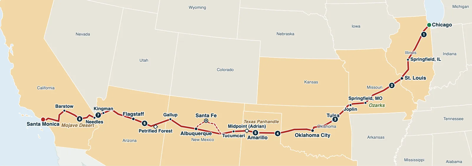
Hover over or tap a state, line or place for details. Use the key to show or hide lines.
Test yourself on this map
Find US States on the Map · Click each state we name
Printable Route 66 Map
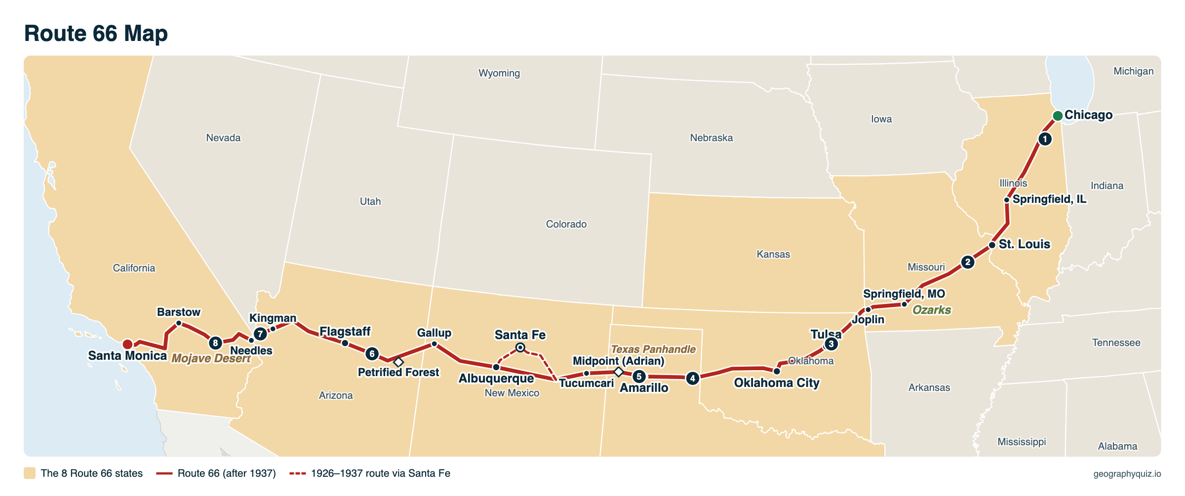
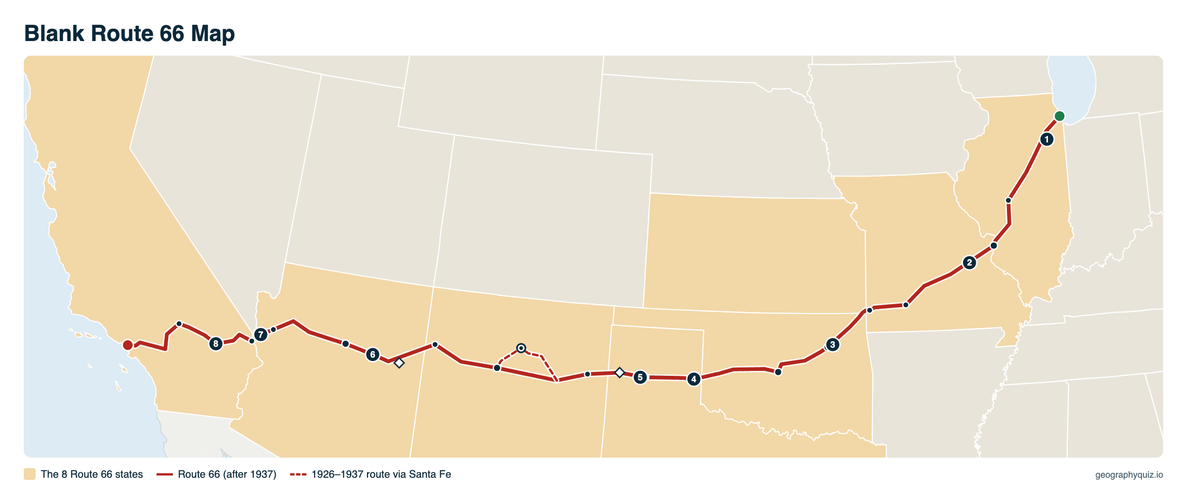
Free to print for planning a road trip or for class: Route 66 from Chicago to Santa Monica with its towns and 8 numbered stops, on one landscape A4 or US Letter page. The blank version keeps the route and the numbers but leaves out the names, so students can label the 8 states and the towns. The blank version has the same map with no names on it, for labeling in class.
Key facts
- Length
- About 2,400 miles (2,448 miles is the usual figure)
- From – to
- Chicago, Illinois – Santa Monica, California
- States
- 8: Illinois, Missouri, Kansas, Oklahoma, Texas, New Mexico, Arizona, California
- Start
- Grant Park, Chicago: the Begin Route 66 sign on Adams Street at Michigan Avenue
- End
- Santa Monica, at Lincoln and Olympic boulevards (since 1936); the End of the Trail sign is on Santa Monica Pier
- Created
- November 11, 1926 (it turned 100 on November 11, 2026)
- Decommissioned
- June 27, 1985
- Nicknames
- The Mother Road, the Main Street of America, the Will Rogers Highway
- Longest state
- New Mexico, about 487 miles; Oklahoma (about 432) has the most miles of the old road still drivable
- Shortest state
- Kansas, 13 miles
Route 66 states and towns
From east to west. Miles are the figures usually given for each state, about 2,450 in all; they are approximate, because the road was moved many times and later alignments were shorter.
| State | Miles | Main towns | Replaced by |
|---|---|---|---|
| Illinois | 301 | Chicago, Joliet, Pontiac, Bloomington, Springfield | I-55 |
| Missouri | 317 | St. Louis, Rolla, Lebanon, Springfield, Carthage, Joplin | I-44 |
| Kansas | 13 | Galena, Riverton, Baxter Springs | – |
| Oklahoma | 432 | Miami, Vinita, Tulsa, Stroud, Oklahoma City, Clinton, Elk City | I-44, I-40 |
| Texas | 186 | Shamrock, McLean, Amarillo, Adrian | I-40 |
| New Mexico | 487 | Tucumcari, Santa Rosa, (Santa Fe until 1937), Albuquerque, Grants, Gallup | I-40 |
| Arizona | 401 | Holbrook, Winslow, Flagstaff, Williams, Seligman, Peach Springs, Kingman, Oatman | I-40 |
| California | 315 | Needles, Amboy, Barstow, Victorville, San Bernardino, Pasadena, Los Angeles, Santa Monica | I-40, I-15, I-10 |
A short history of Route 66
Route 66 was one of the first highways of the new US numbered highway system, approved on November 11, 1926. Tulsa businessman Cyrus Avery pushed for a road linking Chicago with Los Angeles by way of Oklahoma, and the number 66 was chosen in 1926 after a dispute over 60. It was fully paved by 1938.
In the 1930s, families escaping the Dust Bowl drove it west to California; John Steinbeck called it "the mother road" in The Grapes of Wrath (1939). After World War II it became the classic American road trip, with motels, diners and gas stations built for drivers, and the 1946 song "(Get Your Kicks on) Route 66" made it famous. The interstates built from 1956 replaced it piece by piece; the last section, at Williams, Arizona, was bypassed in 1984, and Route 66 was removed from the US highway system on June 27, 1985.
Much of the old road survives as Historic Route 66, marked with brown signs. About 85% of it can still be driven, and many towns along it have restored their neon signs, motels and gas stations.
Where Route 66 starts and ends
Route 66 begins in downtown Chicago, at the edge of Grant Park by Lake Michigan. Its first eastern end was at Jackson Boulevard and Michigan Avenue, and it was later extended to Lake Shore Drive. When Jackson and Adams became one-way streets, westbound drivers started on Adams Street, where the Begin Route 66 sign stands across from the Art Institute.
In 1926 the road ended in downtown Los Angeles, at 7th Street and Broadway. In 1936 it was extended west to Santa Monica, to the corner of Lincoln and Olympic boulevards, about a mile from the ocean: that is the official end. The End of the Trail sign on Santa Monica Pier, put up in 2009, is the end most travelers celebrate, but it was never on the highway.
Route 66 landmarks
The numbers match the circles on the map, from east to west.
- Gemini Giant, Wilmington, Illinois: a giant fiberglass spaceman put up in 1965 outside the Launching Pad Drive-In
- Meramec Caverns, Stanton, Missouri: a show cave advertised on barn roofs all along the road
- Blue Whale of Catoosa, Oklahoma: a smiling concrete whale in a pond, built in the early 1970s
- U-Drop Inn, Shamrock, Texas: a 1936 Art Deco gas station and café, now a visitor center
- Cadillac Ranch, west of Amarillo, Texas: ten graffiti-covered Cadillacs buried nose-first in a field (1974)
- Standin' on the Corner Park, Winslow, Arizona, named for a line in the Eagles' 1972 song "Take It Easy"
- Oatman, Arizona: an old gold-mining town where wild burros wander the main street, on the steep road over Sitgreaves Pass
- Roy's Motel and Café, Amboy, California: a 1938 desert stop with a landmark 1959 sign
Also worth a stop: the Begin Route 66 sign in Chicago, the Chain of Rocks Bridge over the Mississippi with its 22-degree bend, the MidPoint Café in Adrian, Texas, halfway between Chicago and Santa Monica, the Blue Hole, a clear, deep spring in Santa Rosa, New Mexico, Petrified Forest National Park, the only national park on the route, and the Wigwam Motel in nearby Holbrook, Arizona, and the End of the Trail sign on Santa Monica Pier.
Frequently asked questions
What states does Route 66 go through?
Eight: Illinois, Missouri, Kansas, Oklahoma, Texas, New Mexico, Arizona and California, from Chicago to Santa Monica.
How long is Route 66?
About 2,400 miles; 2,448 miles is the figure usually given. The road was rerouted many times, so the length depends on which alignment you follow.
Where does Route 66 officially start and end?
It starts in Chicago, by Grant Park: westbound drivers begin at the Begin Route 66 sign on Adams Street at Michigan Avenue. It officially ends in Santa Monica, California, at Lincoln and Olympic boulevards, where it was extended from downtown Los Angeles in 1936. The End of the Trail sign on Santa Monica Pier is unofficial.
Can you drive all of Route 66?
Most of it. Route 66 is no longer a US highway, but about 85% of the old road can still be driven as Historic Route 66, marked with brown signs. The rest is under or beside the interstates, mostly I-55, I-44 and I-40, which you follow where the old road is gone.
How long does it take to drive Route 66?
About two weeks if you stop to see the towns and landmarks. The road is about 2,400 miles long, mostly two-lane with lower speeds than the interstate, so even without stops it takes at least five or six days of steady driving.
Where is the best place to start driving Route 66?
Most travelers start in Chicago and drive west, the way most guidebooks and the historic markers are arranged, and finish at the Pacific in Santa Monica. For a shorter trip, the western half, from Oklahoma City or Albuquerque to California, has some of the longest stretches of the old road.
Why is Route 66 called the Mother Road?
John Steinbeck called it "the mother road, the road of flight" in The Grapes of Wrath (1939), about families fleeing the Dust Bowl for California.
Which state has the shortest stretch of Route 66?
Kansas, with only 13 miles in its southeastern corner, through Galena, Riverton and Baxter Springs. New Mexico has the longest stretch, about 487 miles, and Oklahoma, with about 432, has the most miles of the old road still drivable.
Where is the midpoint of Route 66?
Adrian, Texas, in the Panhandle west of Amarillo, 1,139 miles from both Chicago and Santa Monica.
When was the Route 66 centennial?
On November 11, 2026, Route 66 turned 100: the US numbered highway system that created it was approved on November 11, 1926.
Sources
- Route: US Census Bureau Gazetteer (town locations) along the post-1937 alignment; the 1926–1937 Santa Fe loop is drawn approximately. Landmarks: National Park Service, Route 66 travel itinerary.
- State boundaries and Interstates: US Census Bureau, cartographic boundary files (2024) and TIGER/Line roads (2023).
- History and miles by state: National Park Service, Route 66 Corridor Preservation Program; Federal Highway Administration, US numbered highway system; state Route 66 associations.