US history · interactive map
Oregon Trail Map
The Oregon Trail route ran about 2,170 miles from Independence, Missouri, to Oregon City in the Willamette Valley. From 1841 to the late 1860s, hundreds of thousands of emigrants walked it beside their covered wagons, a journey of four to six months. Hover over or tap a fort or landmark for its story.
- The 6 Oregon Trail states
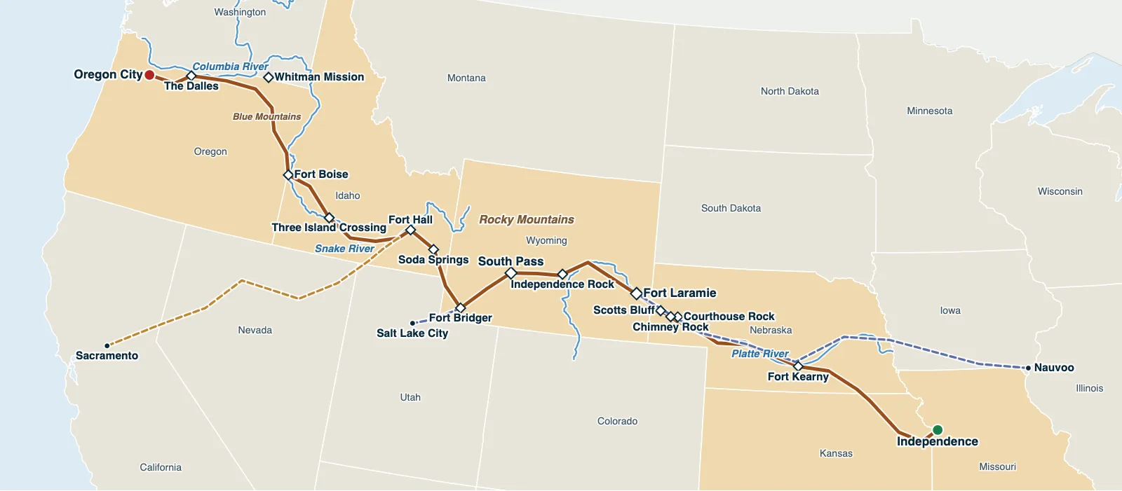
Hover over or tap a state, line or place for details. Use the key to show or hide lines.
Test yourself on this map
Find US States on the Map · Click each state we name
Printable Oregon Trail Map
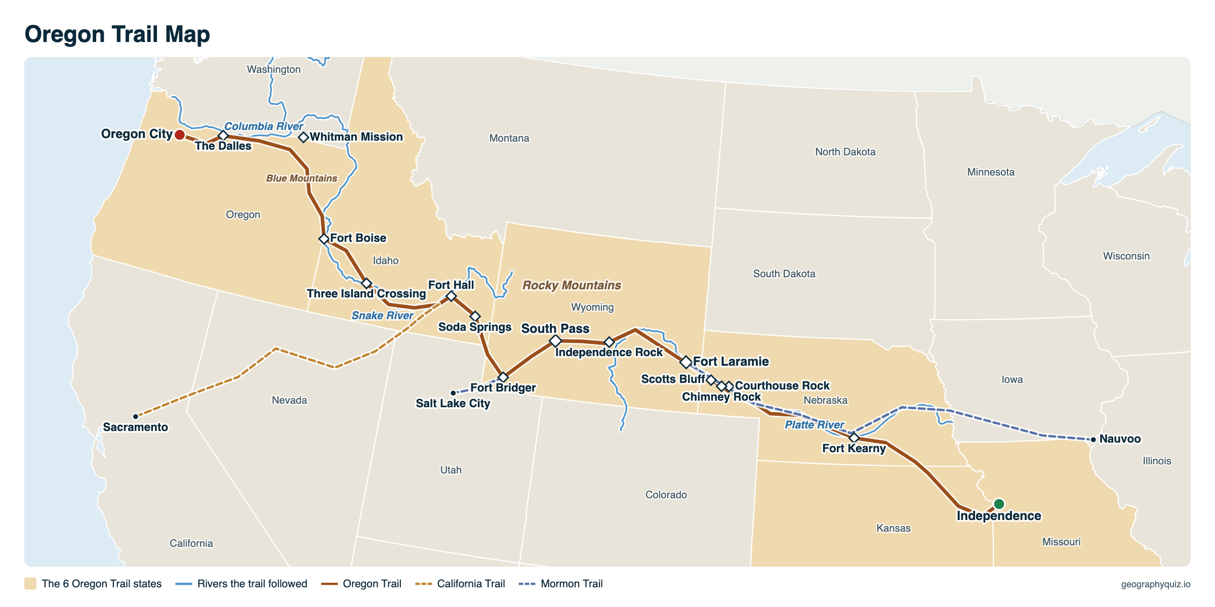
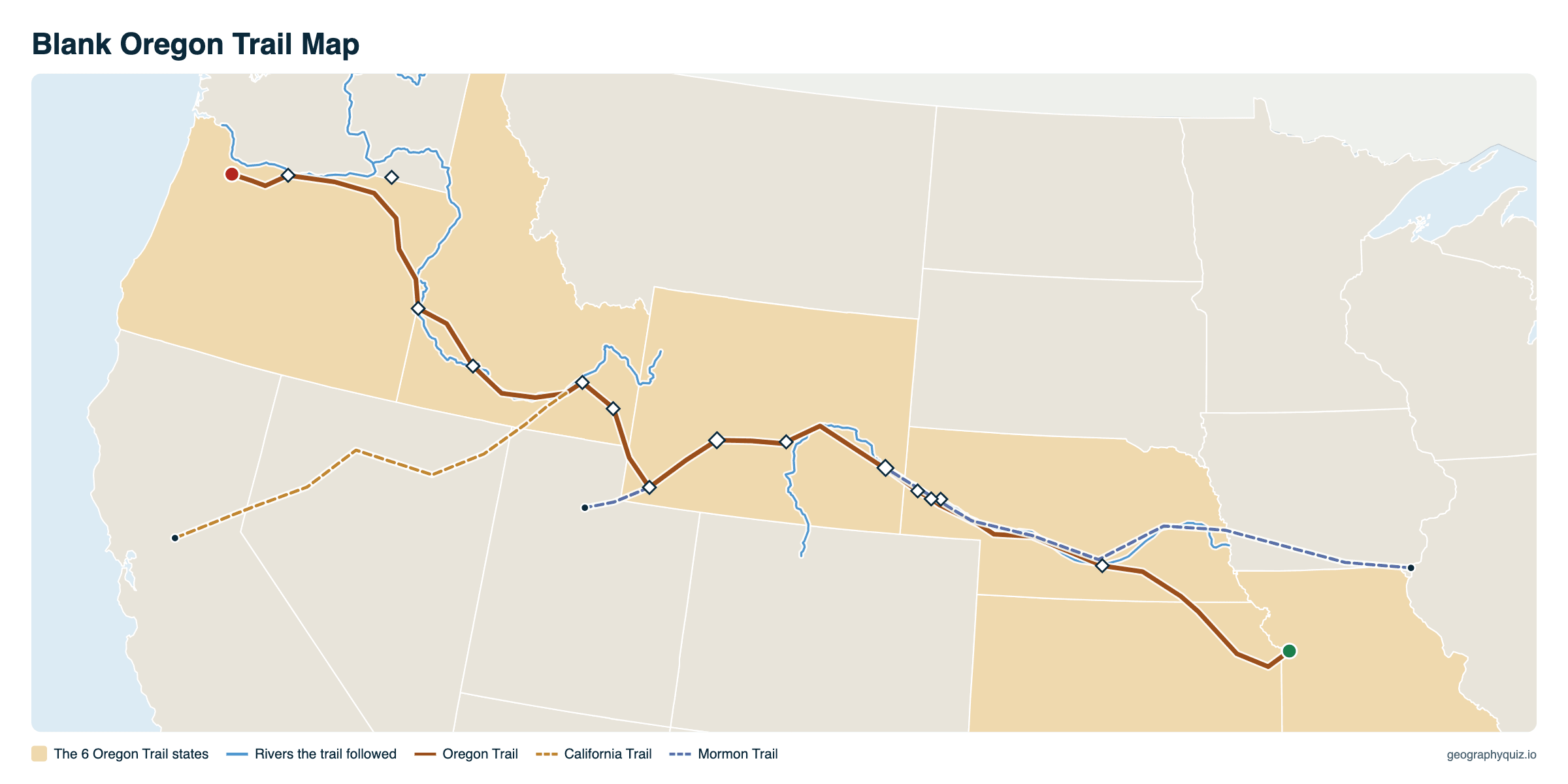
Free to print for class and home: the Oregon Trail with its forts, landmarks and rivers, and the California and Mormon trails, on one landscape A4 or US Letter page. The blank version has the same map with no names on it, for labeling in class.
Key facts
- Length
- About 2,170 miles (3,490 km)
- From – to
- Independence, Missouri – Oregon City, Oregon
- States
- 6: Missouri, Kansas, Nebraska, Wyoming, Idaho, Oregon
- Main years
- 1841 – late 1860s
- Travelers
- About 300,000–400,000 on the Oregon, California and Mormon trails
- Journey
- 4–6 months, about 15 miles a day
- Highest point
- South Pass, Wyoming, 7,412 ft
The Oregon Trail route, stage by stage
- Independence or another Missouri River town: buy a wagon, oxen and about 1,000 pounds of food for a family; leave in April or May, when the prairie grass is high enough to feed the animals.
- Across northeast Kansas to the Platte River in Nebraska, then west along the Platte for about 450 miles: flat, but with storms, mud and cholera.
- Past Courthouse Rock, Chimney Rock and Scotts Bluff to Fort Laramie, Wyoming, about a third of the way, to rest and resupply.
- Up the North Platte and Sweetwater rivers to Independence Rock (reached, ideally, by July 4) and South Pass, the gentle crossing of the Rocky Mountains.
- To Fort Bridger or by the Sublette Cutoff, then Soda Springs and Fort Hall on the Snake River, where the California Trail turned off.
- Along the dry Snake River plain to Three Island Crossing and Fort Boise, then over the Blue Mountains to the Columbia River.
- From The Dalles, down the Columbia by raft or, from 1846, over the Barlow Road around Mount Hood, to Oregon City in the Willamette Valley.
Oregon Trail landmarks and forts
From east to west, the places emigrants looked out for and wrote about in their diaries.
| Landmark | State | What it was |
|---|---|---|
| Independence | Missouri | The best-known jumping-off town, where emigrants bought wagons, oxen and supplies |
| Fort Kearny | Nebraska | Army post on the Platte River, built in 1848 to protect travelers |
| Courthouse and Jail Rocks | Nebraska | The first of the great rock formations along the North Platte |
| Chimney Rock | Nebraska | A tall spire seen for days ahead, the landmark most often named in diaries |
| Scotts Bluff | Nebraska | A towering bluff; wagons went through Mitchell Pass beside it |
| Fort Laramie | Wyoming | Trading post, then army fort: about a third of the way, a place to rest and resupply |
| Independence Rock | Wyoming | A granite dome covered with emigrants' names; the goal was to reach it by July 4 |
| South Pass | Wyoming | The wide, gentle crossing of the Continental Divide |
| Fort Bridger | Wyoming | Jim Bridger's supply post, where the Mormon Trail turned off for Salt Lake City |
| Soda Springs | Idaho | Bubbling mineral springs |
| Fort Hall | Idaho | Trading post on the Snake River, near where the California Trail turned off |
| Three Island Crossing | Idaho | The most dangerous crossing of the Snake River |
| Fort Boise | Idaho | Hudson's Bay Company post near the last crossing of the Snake |
| Blue Mountains | Oregon | A steep, forested climb before the Columbia |
| The Dalles | Oregon | Where emigrants chose between rafting down the Columbia and the Barlow Road |
| Oregon City | Oregon | The end of the trail, in the Willamette Valley |
History of the Oregon Trail
Fur traders and missionaries had crossed the West before, but the first emigrant wagon train set out in 1841, and the Great Migration of 1843 took about 1,000 people to Oregon. Free land drew them: the Donation Land Claim Act of 1850 gave 320 acres to a settler, 640 to a married couple. The 1846 treaty with Britain made Oregon American, and after gold was found in California in 1848 most travelers turned off for the gold fields.
Contrary to films, attacks were rare: disease, above all cholera, accidents and drownings caused most deaths, perhaps up to one emigrant in ten. Most people walked the whole way beside wagons pulled by oxen. Traffic fell after the first transcontinental railroad opened in 1869, though some families used the trail into the 1880s. Today it is the Oregon National Historic Trail, and wagon ruts can still be seen at places such as Guernsey, Wyoming.
Frequently asked questions
What was the starting point for the Oregon Trail?
Towns on the Missouri River, best known Independence, Missouri; others set out from Westport (today's Kansas City), St. Joseph or Council Bluffs. The trail ended at Oregon City in Oregon's Willamette Valley, near today's Portland.
How long was the Oregon Trail?
About 2,170 miles (3,490 km). Wagons covered about 15 miles a day, so the trip took four to six months.
What states did the Oregon Trail go through?
Six of today's states: Missouri, Kansas, Nebraska, Wyoming, Idaho and Oregon.
When was the Oregon Trail used?
Mainly from 1841 to the late 1860s. The Great Migration of 1843 took about 1,000 people; traffic peaked around 1850 and fell after the transcontinental railroad opened in 1869.
How many people traveled the Oregon Trail?
About 300,000 to 400,000 emigrants traveled the Oregon, California and Mormon trails together, which shared much of the route; about 80,000 went to Oregon.
How many people survived the Oregon Trail?
Most of them. Estimates vary, but perhaps up to one emigrant in ten died on the way, mostly from disease, above all cholera, and from accidents such as drownings at river crossings and falls under wagon wheels. Attacks by Native Americans caused few deaths.
Can you still walk the Oregon Trail?
You can visit much of it. The route is the Oregon National Historic Trail, run by the National Park Service with many partners, and an auto tour route follows it from Missouri to Oregon. Wagon ruts can still be seen and walked at places such as Guernsey, Wyoming, and many landmarks, from Chimney Rock to Fort Laramie and the End of the Oregon Trail center in Oregon City, are open to visitors.
What was the hardest part of the Oregon Trail?
River crossings such as the Snake at Three Island Crossing, the Blue Mountains and the last stretch past Mount Hood or down the Columbia. Disease, especially cholera along the Platte, killed far more people than anything else.
What is South Pass?
A broad, gentle saddle across the Continental Divide in Wyoming at 7,412 feet. It let wagons cross the Rocky Mountains without steep climbs, which is what made the Oregon Trail possible.
Sources
- Route: drawn after the National Park Service's Oregon National Historic Trail maps, through the forts and landmarks listed; the California and Mormon trails are drawn approximately.
- Town locations: US Census Bureau Gazetteer; state boundaries: US Census Bureau, cartographic boundary files (2024).
- History and numbers: National Park Service, Oregon, California and Mormon Pioneer National Historic Trails; Oregon Historical Society.