US history · interactive map
Louisiana Purchase Map
In 1803 the United States bought about 828,000 square miles west of the Mississippi River from France for $15 million, doubling the size of the country. The brown line is its border as settled with Britain and Spain in 1818 and 1819; all or part of 15 of today's states came from it. Hover over or tap a state to see how much.
- Entirely or almost entirely in the Purchase
- Partly in the Purchase
- Partly claimed in 1803, left to Spain in 1819
- The United States in 1803
States are drawn with their modern borders; hatched states are partly in the Purchase. The border line is approximate: the 1803 treaty did not fix one, and the borders shown are those settled with Britain in 1818 and Spain in 1819.
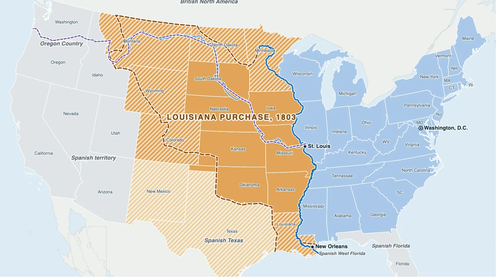
Hover over or tap a state, line or place for details. Use the key to show or hide lines.
Test yourself on this map
Find US States on the Map · Click each state we name
Printable Louisiana Purchase Map
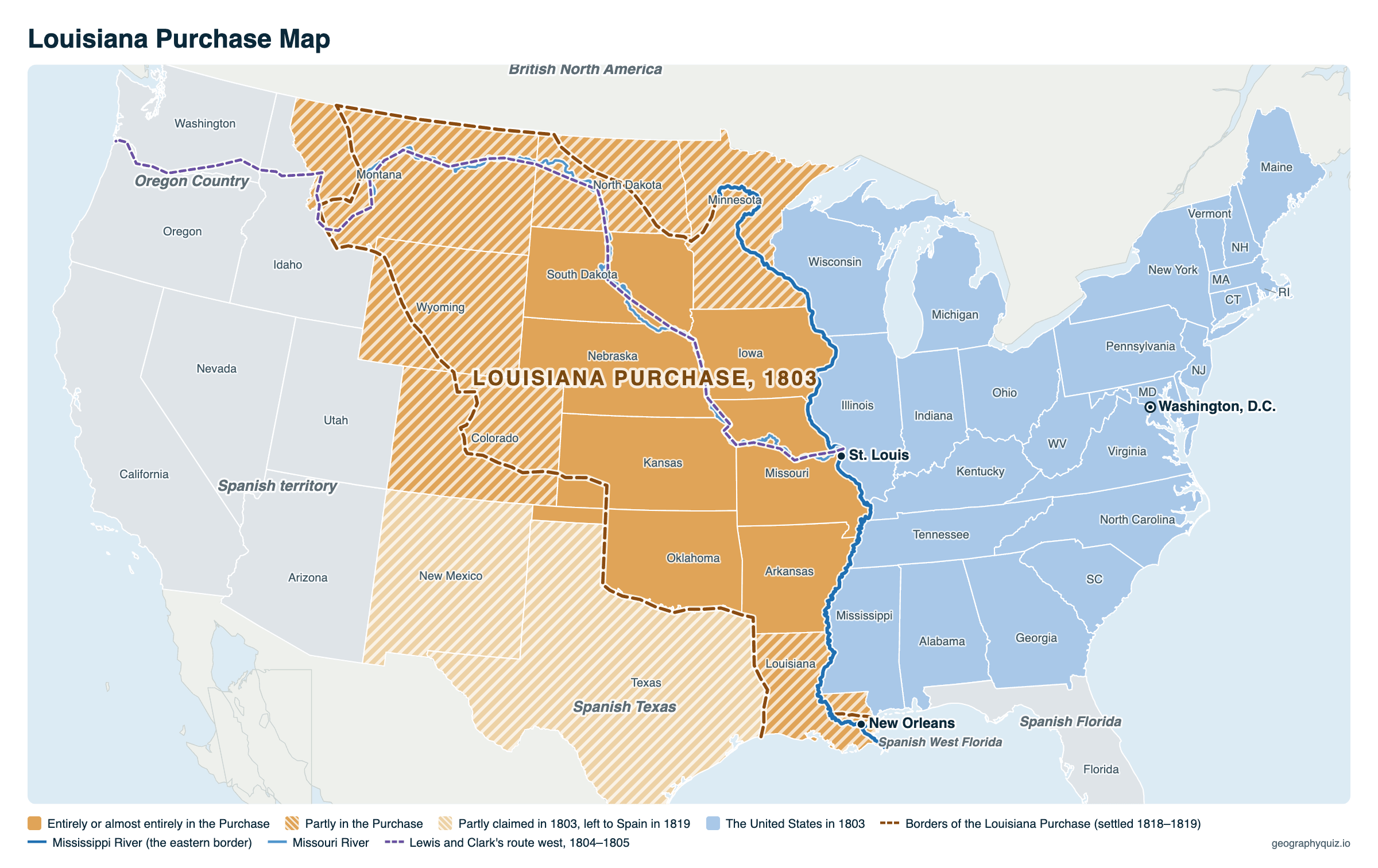
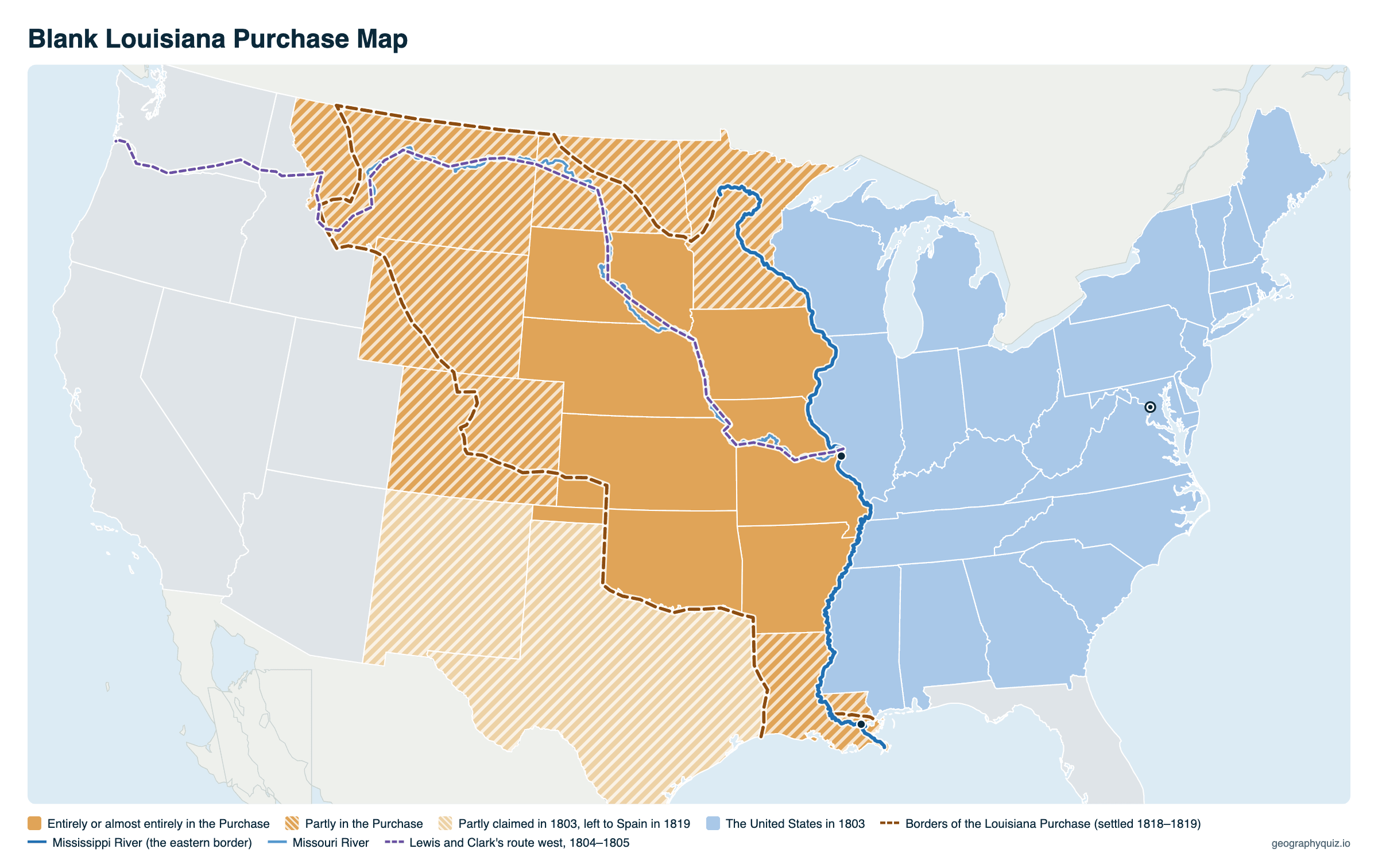
Free to print for class and home: the Louisiana Purchase and its borders, the states made from it, Lewis and Clark's route and the United States of 1803, on one landscape A4 or US Letter page. The blank version has the same map with no names on it, for labeling in class.
Key facts
- Bought from
- France (Napoleon Bonaparte)
- Price
- $15 million (about 3 cents an acre)
- Area
- About 828,000 sq mi (2.1 million km²), about 530 million acres
- Treaty signed
- April 30, 1803, in Paris (dated; signed May 2)
- Ratified by the Senate
- October 20, 1803
- President
- Thomas Jefferson
- States made from it
- 15, wholly or partly
Which states were part of the Louisiana Purchase?
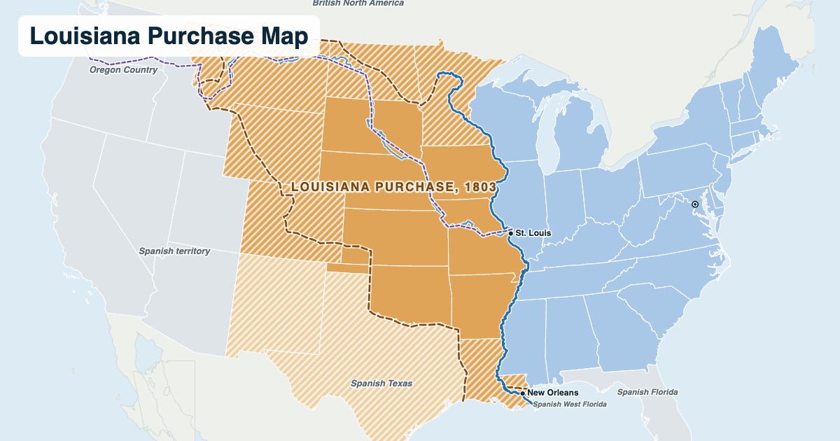
All or part of 15 states, counting the parts of Texas and New Mexico that were claimed in 1803 and given up to Spain in 1819. The states' borders were drawn later, so most of the western ones are only partly inside it.
| State | How much | Statehood |
|---|---|---|
| Arkansas | All | 1836 |
| Iowa | All | 1846 |
| Missouri | All | 1821 |
| Nebraska | All | 1867 |
| South Dakota | Almost all | 1889 |
| Oklahoma | All but the Panhandle | 1907 |
| Kansas | Most | 1861 |
| Minnesota | West of the Mississippi, except the Red River valley | 1858 |
| North Dakota | Most (the Missouri basin) | 1889 |
| Montana | East of the Continental Divide | 1889 |
| Wyoming | East of the Continental Divide | 1890 |
| Colorado | Northeast (east of the Rockies, north of the Arkansas River) | 1876 |
| Louisiana | West of the Mississippi, with New Orleans | 1812 |
| New Mexico | The northeast (claimed in 1803, Spanish from 1819) | 1912 |
| Texas | The north (claimed in 1803, Spanish from 1819) | 1845 |
Why did the United States buy Louisiana?
Farmers west of the Appalachians shipped their crops down the Mississippi River, and New Orleans controlled its mouth. When Spain handed Louisiana back to France in 1800 and New Orleans was closed to American goods in 1802, President Thomas Jefferson sent James Monroe to Paris to join Robert Livingston and offer up to $10 million for New Orleans and West Florida.
Napoleon, who had lost an army to the revolution in Haiti and was about to go to war with Britain again, offered the whole of Louisiana instead. The Americans agreed to $15 million: $11.25 million in cash and the rest by taking on claims American citizens had against France. The treaty is dated April 30, 1803; the Senate ratified it on October 20, and the US took over New Orleans on December 20, 1803, and St. Louis on March 10, 1804.
The borders of the Louisiana Purchase
The treaty did not say exactly where Louisiana ended. In practice it was the western half of the Mississippi River basin: the land drained by the Missouri, Arkansas and Red rivers, from the Mississippi to the Continental Divide in the Rocky Mountains. The 1818 treaty with Britain set the northern border at the 49th parallel, and the Adams–Onís Treaty with Spain in 1819 fixed the southwestern border along the Sabine, Red and Arkansas rivers.
To explore it, Jefferson sent Meriwether Lewis and William Clark up the Missouri River in 1804; their Corps of Discovery crossed the Purchase and the Rockies and reached the Pacific in November 1805.
Frequently asked questions
How big was the Louisiana Purchase?
About 828,000 square miles (2.1 million km²), roughly 530 million acres. It doubled the size of the United States and is almost a quarter of the country's land today.
How much did the Louisiana Purchase cost?
$15 million: $11.25 million paid to France and $3.75 million in French debts to American citizens that the US took on. That works out to about 3 cents an acre.
Who sold the Louisiana Purchase?
France, under Napoleon Bonaparte. Spain had owned Louisiana from 1762 and gave it back to France in 1800, shortly before the sale.
How many states were made from the Louisiana Purchase?
All or part of 15: Arkansas, Iowa, Missouri, Nebraska, South Dakota, Oklahoma and Kansas almost entirely, and parts of Minnesota, North Dakota, Montana, Wyoming, Colorado, Louisiana, New Mexico and Texas.
What states and territories were in the Louisiana Purchase?
In 1804 the US divided it into the Territory of Orleans (today's Louisiana) and the District of Louisiana, later the Louisiana and then Missouri Territory. All of Arkansas, Iowa, Missouri, Nebraska and almost all of South Dakota, Oklahoma and Kansas came from it, with parts of Minnesota, North Dakota, Montana, Wyoming, Colorado and Louisiana, and the claim at first reached into Texas and New Mexico.
Which president doubled the size of the United States?
Thomas Jefferson. The Louisiana Purchase of 1803 added about 828,000 square miles and roughly doubled the country's size.
Was the Louisiana Purchase larger than Alaska?
Yes. At about 828,000 square miles it was roughly a quarter larger than Alaska (about 665,000 square miles), which the US bought from Russia in 1867 for $7.2 million.
Did the Louisiana Purchase include part of Canada?
Yes, a little. The Missouri River's basin reaches north of the 49th parallel into today's Alberta and Saskatchewan. The 1818 treaty with Britain made the 49th parallel the border, so that land went to Britain and the Red River valley to its south became American.
What river was the eastern border of the Louisiana Purchase?
The Mississippi River, except at its mouth, where New Orleans on the east bank was included.
When was the Louisiana Purchase?
The treaty is dated April 30, 1803. The Senate ratified it on October 20, 1803, and the US formally took possession of New Orleans on December 20, 1803.
Sources
- State boundaries and the Mississippi and Missouri rivers: US Census Bureau, cartographic boundary files (2024), and the rivers of our US map.
- Price, area and dates: National Archives (Louisiana Purchase Treaty, 1803) and the US Department of State, Office of the Historian.
- States in the Purchase: US Geological Survey and Bureau of Land Management, Public Land Statistics (acquisition of the public domain).