US geography · interactive map
Mississippi River Map
The Mississippi River flows about 2,340 miles from Lake Itasca in Minnesota to the Gulf of Mexico below New Orleans, through or along 10 states. With the Missouri, the Ohio and its other tributaries it drains about 40% of the lower 48 states. Hover over or tap a city, state or tributary for details.
- The 10 states along the Mississippi
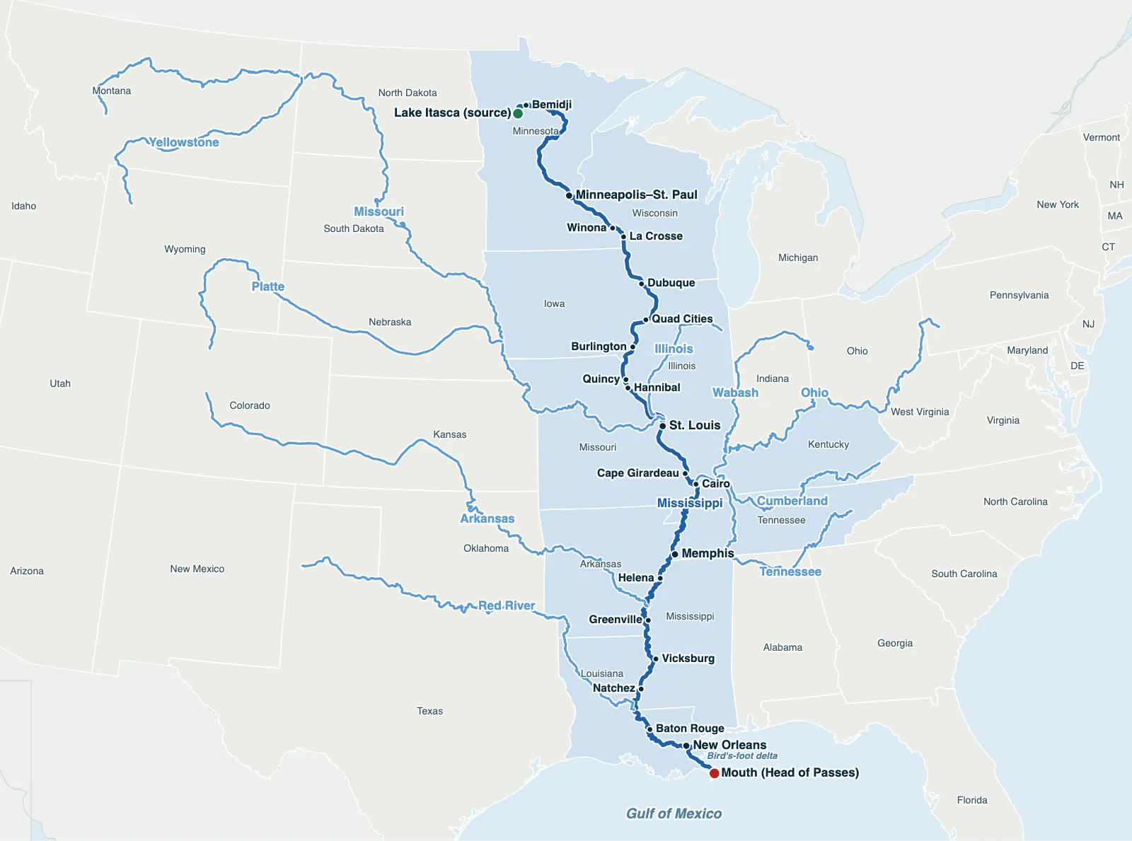
Hover over or tap a state, line or place for details. Use the key to show or hide lines.
Test yourself on this map
US Rivers Quiz · Find the major rivers on the map
Printable Mississippi River Map
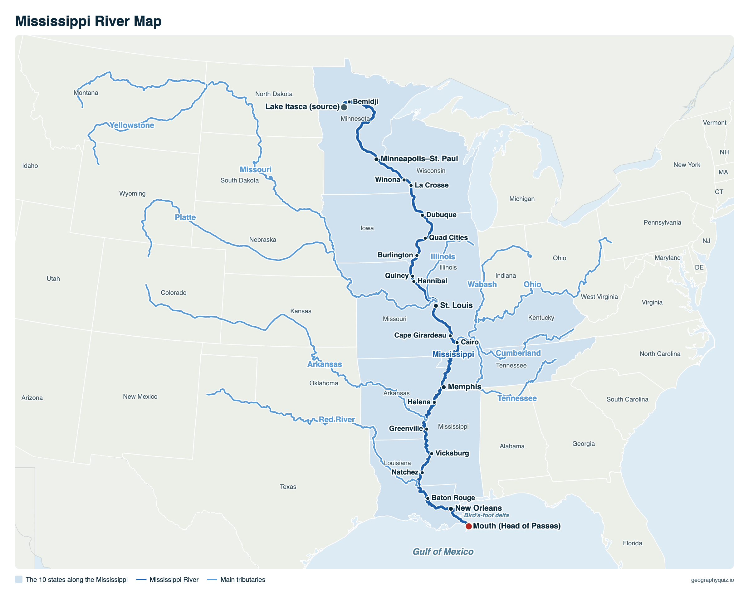
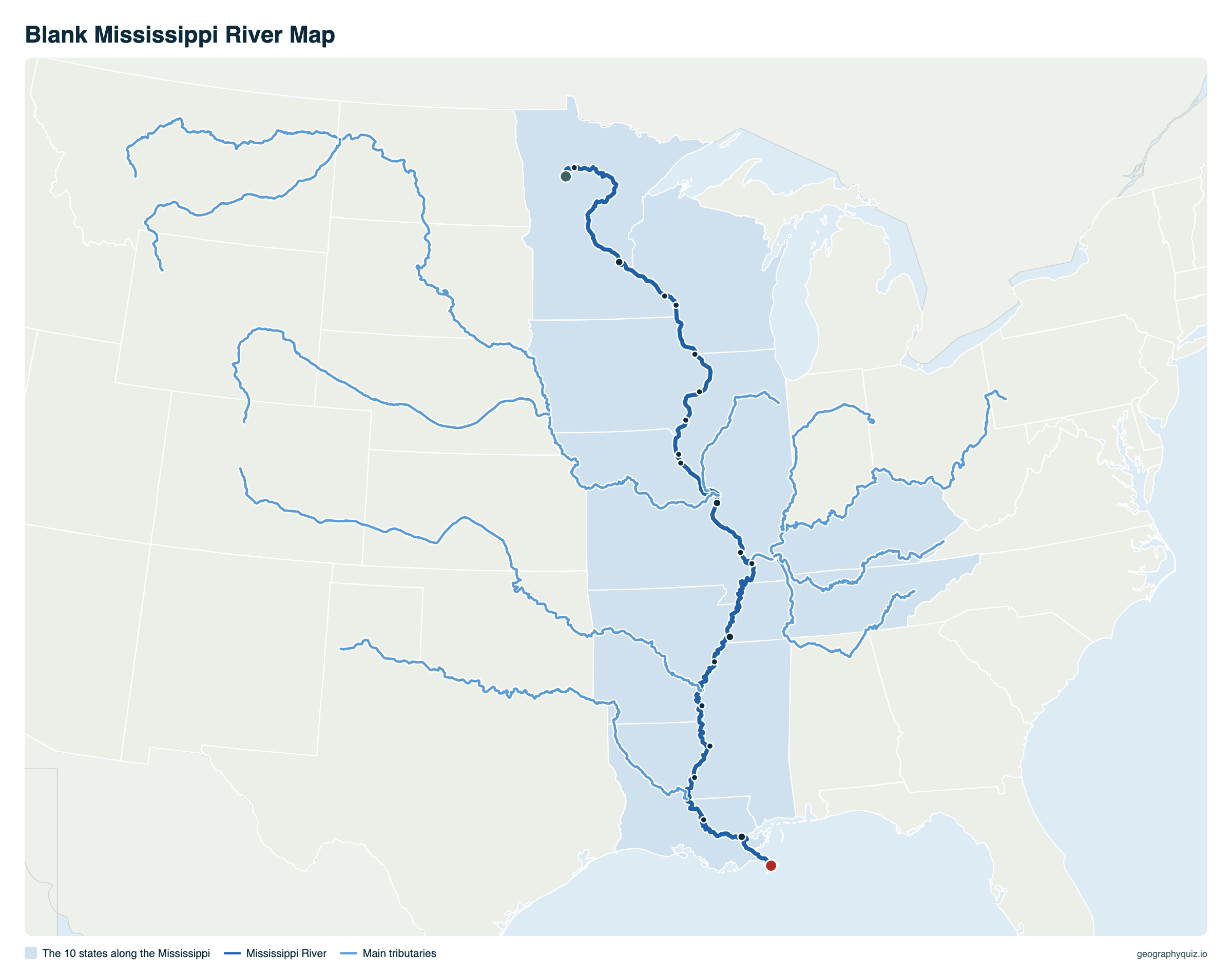
Free to print for class and home: the Mississippi from source to mouth with its states, cities and main tributaries, on one landscape page, labeled or blank. The blank version has the same map with no names on it, for labeling in class.
Key facts
- Length
- 2,340 mi (3,766 km)
- Source
- Lake Itasca, Minnesota (1,475 ft)
- Mouth
- Gulf of Mexico, about 95 miles below New Orleans
- States along it
- 10
- Basin
- All or part of 31 states and 2 Canadian provinces, about 1.2 million sq mi
- Largest tributaries
- Missouri (longest), Ohio (most water)
- Locks and dams
- 29 on the Upper Mississippi, between Minneapolis and St. Louis
States along the Mississippi River
From north to south. The river forms part of the border of every state it touches except Minnesota and Louisiana, where it also flows through.
| State | Side | River cities |
|---|---|---|
| Minnesota | Both banks, then the border with Wisconsin | Bemidji, Minneapolis, St. Paul, Red Wing, Winona |
| Wisconsin | East bank | La Crosse, Prairie du Chien |
| Iowa | West bank | Dubuque, Davenport, Burlington |
| Illinois | East bank | Moline, Rock Island, Quincy, East St. Louis, Cairo |
| Missouri | West bank | Hannibal, St. Louis, Cape Girardeau |
| Kentucky | East bank | Wickliffe, Hickman |
| Tennessee | East bank | Memphis |
| Arkansas | West bank | Helena-West Helena |
| Mississippi | East bank | Greenville, Vicksburg, Natchez |
| Louisiana | West bank, then both banks | Baton Rouge, New Orleans |
From source to sea
The Mississippi starts as a stream a few feet wide flowing out of Lake Itasca in northern Minnesota, where visitors walk across it on stepping stones. It first flows north, then curves south through a string of lakes; at Minneapolis it drops over St. Anthony Falls, the only waterfall on the river, and from there boats can travel all the way to the Gulf through a staircase of 29 locks and dams.
The Missouri joins just above St. Louis and the Ohio at Cairo, Illinois, where the river roughly doubles in volume. Below Cairo, the Lower Mississippi winds through a wide floodplain lined with levees, past Memphis, Vicksburg and Natchez. At Old River, Louisiana, a control structure stops the river from switching to the shorter Atchafalaya. It reaches the Gulf of Mexico through the passes of its bird's-foot delta, about 95 miles below New Orleans.
Upper and Lower Mississippi
The river is usually split in two at Cairo, Illinois, where the Ohio joins. The Upper Mississippi runs from Lake Itasca to Cairo. Above St. Louis it is a chain of pools held back by locks and dams, with bluffs on both sides for much of the way, and the US Army Corps of Engineers keeps a channel at least 9 feet deep for barges from Baton Rouge all the way up to Minneapolis.
The Lower Mississippi, from Cairo to the Gulf, has no dams. It loops across a broad, flat valley held in by levees, and below Baton Rouge a channel 45 feet deep lets oceangoing ships reach the ports between New Orleans and Baton Rouge, among the busiest in the country.
Main tributaries of the Mississippi
| River | Length | Joins the Mississippi |
|---|---|---|
| Missouri | 2,540 mi | Just north of St. Louis, Missouri |
| Ohio | 981 mi | Cairo, Illinois |
| Arkansas | 1,460 mi | Southeast Arkansas |
| Red | 1,290 mi | Through the Atchafalaya, Louisiana |
| Illinois | 273 mi | Grafton, Illinois |
| Tennessee (to the Ohio) | 652 mi | Joins the Ohio at Paducah, Kentucky |
Mississippi River facts
- Length: the US Geological Survey gives 2,340 miles; other agencies give anything from 2,300 to 2,350, because the delta grows and shrinks and the river's bends are cut off and re-formed.
- Width: 20 to 30 feet where it leaves Lake Itasca, and more than 11 miles at Lake Winnibigoshish in Minnesota; on the Lower Mississippi it is usually half a mile to a mile wide.
- Speed: about 1.2 miles per hour near the source and about 3 miles per hour at New Orleans. A drop of water takes about three months to travel from Lake Itasca to the Gulf.
- Flow: about 600,000 cubic feet of water a second at New Orleans, more than any other river in the United States.
- Wildlife: at least 260 kinds of fish live in the river, and about 60% of North America's bird species use its basin as a flyway on their spring and fall migrations.
Frequently asked questions
Where does the Mississippi River start and end?
It starts at Lake Itasca in northern Minnesota and ends in the Gulf of Mexico, about 95 miles below New Orleans, Louisiana.
How long is the Mississippi River?
About 2,340 miles (3,766 km), the second-longest river in the United States after the Missouri. Measured together with the Missouri, the system is about 3,700 to 3,900 miles long, depending on how it is measured, the fourth-longest in the world.
What states does the Mississippi River go through?
Ten: Minnesota, Wisconsin, Iowa, Illinois, Missouri, Kentucky, Tennessee, Arkansas, Mississippi and Louisiana.
Where is the Mississippi River Delta?
In southeastern Louisiana, where the river meets the Gulf of Mexico. At its tip, below New Orleans, the river splits at Head of Passes into channels such as Southwest Pass and South Pass, which spread out like a bird's foot. The name also covers the wider delta plain the river has built over thousands of years, most of coastal Louisiana. It is not the same as the Mississippi Delta, the farming region in northwest Mississippi.
Are there alligators in the Mississippi River?
Yes, along the lower river. American alligators live in the swamps, bayous, lakes and backwaters of the lower Mississippi valley in Louisiana, Mississippi and eastern Arkansas, near the northern edge of their range. There are none on the Upper Mississippi.
Where do the Missouri and Mississippi rivers meet?
Just north of St. Louis, Missouri, near the town of West Alton. The Ohio joins farther south, at Cairo, Illinois, and brings even more water than the Missouri.
What is the largest tributary of the Mississippi?
The Missouri is the longest, but the Ohio carries the most water: below Cairo, Illinois, where it joins, more of the river's water comes from the Ohio than from the Upper Mississippi.
What cities are on the Mississippi River?
The largest are Minneapolis and St. Paul, St. Louis, Memphis, Baton Rouge and New Orleans. Others include La Crosse, Dubuque, the Quad Cities (Davenport and Moline), Burlington, Quincy, Hannibal, Cape Girardeau, Vicksburg and Natchez.
How long does it take water to travel down the Mississippi?
About three months from Lake Itasca to the Gulf of Mexico. The current is slowest near the source, at about 1.2 miles per hour, and faster on the lower river, about 3 miles per hour at New Orleans.
Sources
- River lines: the rivers of our US map; state boundaries: US Census Bureau, cartographic boundary files (2024); city locations: US Census Bureau Gazetteer.
- Length: US Geological Survey, Largest Rivers in the United States (Open-File Report 87-242).
- Basin, width, speed, flow, wildlife, locks and dams: National Park Service, Mississippi National River and Recreation Area; channel depths: US Army Corps of Engineers.
- Alligators: Mississippi Department of Wildlife, Fisheries, and Parks; US Fish and Wildlife Service.