US geography · interactive map
US Rivers Map
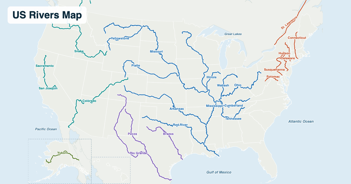
The major rivers of the United States, labeled and colored by where they flow: the Mississippi system to the Gulf of Mexico, the rivers of the West to the Pacific, the Texas rivers to the Gulf, the eastern rivers and the St. Lawrence to the Atlantic, and the Yukon to the Bering Sea. Hover over or tap a river for its length, source and mouth.
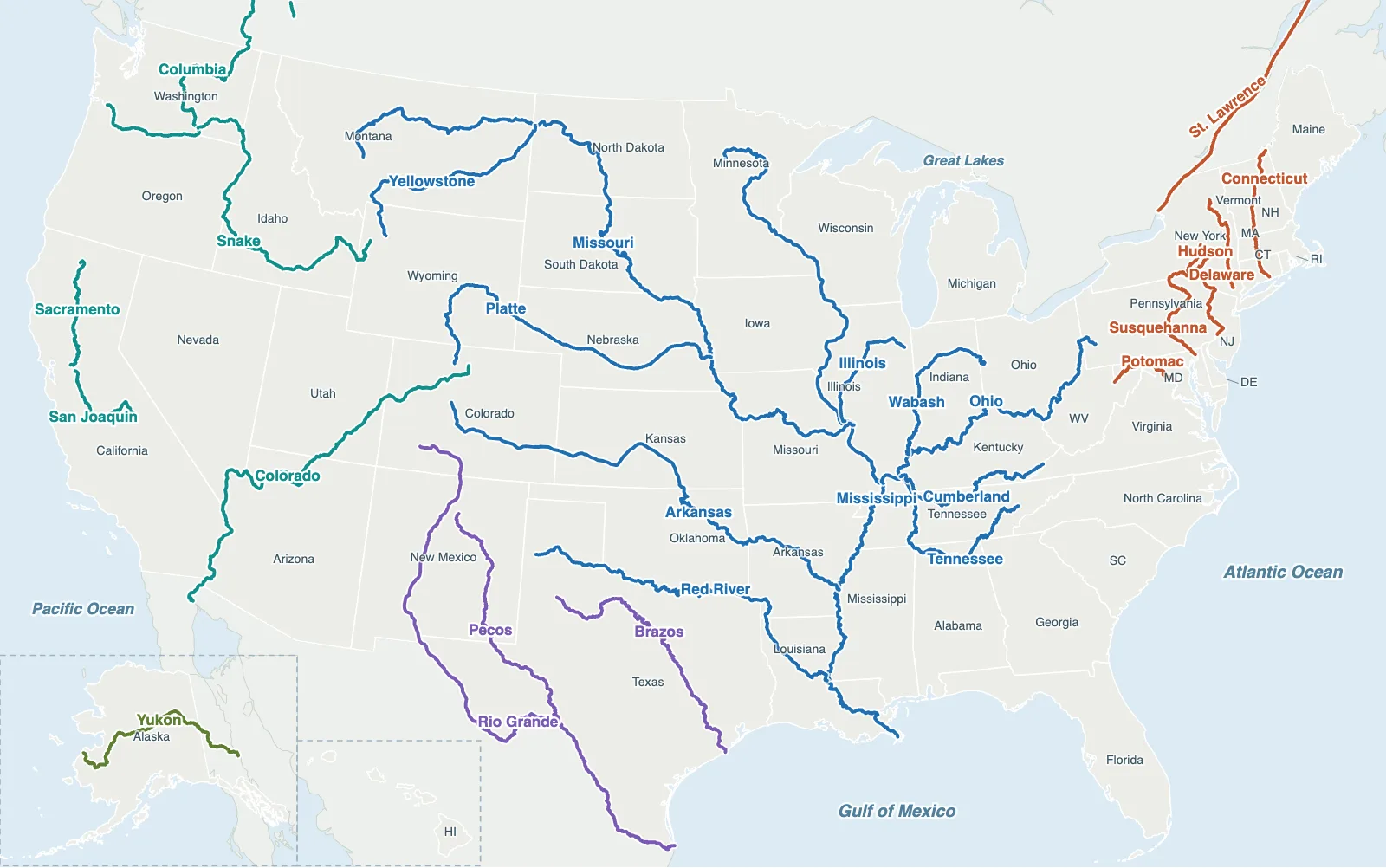
Hover over or tap a state, line or place for details. Use the key to show or hide lines.
Test yourself on this map
US Rivers Quiz · Find the major rivers on the map
Printable US Rivers Map
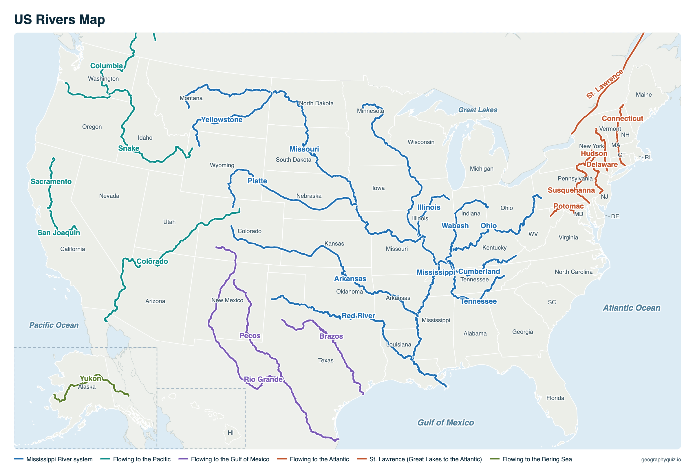
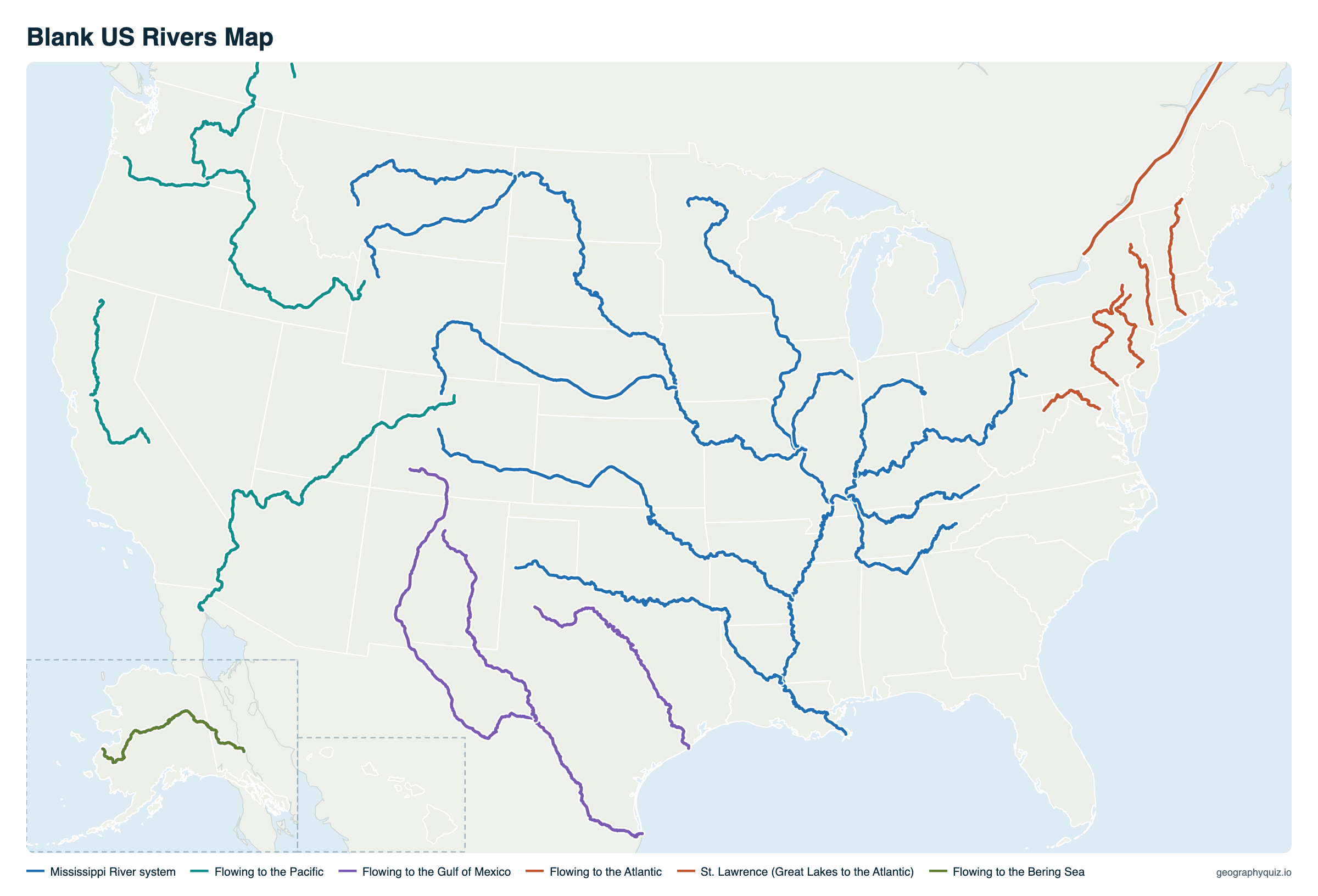
Free to print for class and home: the 26 major US rivers colored by where they flow, with the states, on one landscape page, labeled or blank. The blank version has the same map with no names on it, for labeling in class.
Key facts
- Longest river
- Missouri, 2,540 mi (4,088 km)
- Second longest
- Mississippi, 2,340 mi (3,766 km)
- Mississippi–Missouri system
- About 3,700 to 3,900 mi depending on how it is measured, the fourth-longest in the world
- Largest by flow
- Mississippi, then the St. Lawrence, Ohio and Columbia
- Continental Divide
- Rivers east of it flow to the Atlantic or the Gulf of Mexico; west of it, to the Pacific
- Rivers on the map
- 26
Longest rivers in the United States
The rivers on the map, from longest to shortest, with where each one rises and ends. River lengths depend on where the source and mouth are put, so other books may give slightly different figures.
| River | Length | Source | Mouth | States |
|---|---|---|---|---|
| Missouri | 2,540 mi (4,088 km) | Red Rock headwaters near Brower’s Spring, Montana | Mississippi River, near St. Louis | Montana, North Dakota, South Dakota, Nebraska, Iowa, Kansas, Missouri |
| Mississippi | 2,340 mi (3,766 km) | Lake Itasca, Minnesota | Gulf of Mexico | Minnesota, Wisconsin, Iowa, Illinois, Missouri, Kentucky, Tennessee, Arkansas, Mississippi, Louisiana |
| Yukon | 1,980 mi (3,187 km) | Atlin and Tagish lakes, British Columbia | Bering Sea | Alaska (and Canada) |
| Rio Grande | 1,900 mi (3,058 km) | San Juan Mountains, Colorado | Gulf of Mexico | Colorado, New Mexico, Texas |
| Arkansas | 1,460 mi (2,350 km) | Rocky Mountains near Leadville, Colorado | Mississippi River | Colorado, Kansas, Oklahoma, Arkansas |
| Colorado | 1,450 mi (2,334 km) | Rocky Mountain National Park, Colorado | Gulf of California | Colorado, Utah, Arizona, Nevada, California |
| Red | 1,290 mi (2,076 km) | Llano Estacado, Curry County, New Mexico | Atchafalaya and Mississippi rivers, Louisiana | New Mexico, Texas, Oklahoma, Arkansas, Louisiana |
| Brazos | 1,280 mi (2,060 km) | Llano Estacado, eastern New Mexico | Gulf of Mexico | New Mexico, Texas |
| Columbia | 1,240 mi (1,996 km) | Columbia Lake, British Columbia | Pacific Ocean | Washington, Oregon (and Canada) |
| Snake | 1,040 mi (1,674 km) | Yellowstone National Park, Wyoming | Columbia River | Wyoming, Idaho, Oregon, Washington |
| Platte | 990 mi (1,593 km) | Rocky Mountains, Colorado (North Platte headwaters) | Missouri River | Colorado, Wyoming, Nebraska |
| Ohio | 981 mi (1,579 km) | Pittsburgh, Pennsylvania (Allegheny and Monongahela) | Mississippi River at Cairo, Illinois | Pennsylvania, Ohio, West Virginia, Kentucky, Indiana, Illinois |
| Pecos | 926 mi (1,490 km) | Sangre de Cristo Mountains, New Mexico | Rio Grande | New Mexico, Texas |
| St. Lawrence | 744 mi (1,197 km); about 1,900 mi counted from the head of the Great Lakes | Lake Ontario | Gulf of St. Lawrence (Atlantic Ocean) | New York (and Canada) |
| Yellowstone | 692 mi (1,114 km) | Absaroka Range, Wyoming | Missouri River | Wyoming, Montana, North Dakota |
| Cumberland | 688 mi (1,107 km) | Harlan, Kentucky (Poor, Clover and Martins forks) | Ohio River at Smithland, Kentucky | Kentucky, Tennessee |
| Tennessee | 652 mi (1,049 km) | Knoxville, Tennessee (confluence of the Holston and French Broad) | Ohio River at Paducah, Kentucky | Tennessee, Alabama, Mississippi, Kentucky |
| Wabash | 503 mi (810 km) | Near Fort Recovery, Ohio | Ohio River | Ohio, Indiana, Illinois |
| Susquehanna | 444 mi (715 km) | Otsego Lake, New York | Chesapeake Bay | New York, Pennsylvania, Maryland |
| Connecticut | 410 mi (660 km) | Fourth Connecticut Lake, New Hampshire | Long Island Sound | New Hampshire, Vermont, Massachusetts, Connecticut |
| Sacramento | 384 mi (618 km) | Klamath Mountains near Mount Shasta | Suisun Bay (San Francisco Bay) | California |
| Potomac | 383 mi (616 km) | Fairfax Stone, West Virginia (North Branch) | Chesapeake Bay | West Virginia, Maryland, Virginia, District of Columbia |
| San Joaquin | 366 mi (589 km) | Sierra Nevada, California | Suisun Bay (San Francisco Bay) | California |
| Delaware | 330 mi (531 km) | Hancock, New York (East and West branches, Catskill Mountains) | Atlantic Ocean, through Delaware Bay | New York, Pennsylvania, New Jersey, Delaware |
| Hudson | 315 mi (507 km) | Lake Tear of the Clouds, Adirondack Mountains | Upper New York Bay (Atlantic Ocean) | New York, New Jersey |
| Illinois | 273 mi (439 km) | Confluence of the Des Plaines and Kankakee, Illinois | Mississippi River at Grafton | Illinois |
Where US rivers flow
The Continental Divide, along the crest of the Rocky Mountains, splits the country's rivers in two. To the east, almost everything between the Rockies and the Appalachians drains into the Mississippi: its basin covers all or part of 31 states and two Canadian provinces, about 40% of the lower 48 states. The Missouri, the Ohio, the Arkansas and the Red are its biggest tributaries.
East of the Appalachians, shorter rivers such as the Hudson, the Delaware, the Susquehanna and the Potomac flow straight to the Atlantic, many through bays like the Chesapeake. The Great Lakes empty through the St. Lawrence, which carries more water to the sea than any US river except the Mississippi. West of the Divide, the Columbia and its tributary the Snake drain the Northwest to the Pacific, and the Colorado carves the Grand Canyon on its way to the Gulf of California. The Rio Grande, joined by the Pecos, forms the Texas–Mexico border, and the Yukon crosses Alaska to the Bering Sea.
Major US rivers by where they flow
| Drains to | Rivers |
|---|---|
| Mississippi River (Gulf of Mexico) | Missouri, Ohio, Arkansas, Red, Illinois; the Platte and Yellowstone through the Missouri; the Tennessee, Cumberland and Wabash through the Ohio |
| Pacific Ocean (and Gulf of California) | Columbia (with the Snake), Sacramento and San Joaquin (through San Francisco Bay), Colorado (to the Gulf of California) |
| Gulf of Mexico (directly) | Mississippi, Rio Grande, Brazos |
| Rio Grande | Pecos |
| Atlantic Ocean | Hudson, Delaware, Connecticut (through Long Island Sound), Susquehanna and Potomac (through Chesapeake Bay), St. Lawrence (from the Great Lakes) |
| Bering Sea | Yukon |
Rivers that form state borders
Many state lines follow rivers, which is why the borders of the middle of the country wiggle while those of the West are straight.
| River | Border it forms |
|---|---|
| Mississippi | Minnesota–Wisconsin, Iowa–Wisconsin, Iowa–Illinois, Missouri–Illinois, Missouri–Kentucky, Missouri–Tennessee, Arkansas–Tennessee, Arkansas–Mississippi and part of Louisiana–Mississippi |
| Ohio | Kentucky's whole northern border with Ohio, Indiana and Illinois, and Ohio–West Virginia |
| Missouri | Nebraska–Iowa, Nebraska–Missouri, Kansas–Missouri and part of Nebraska–South Dakota |
| Rio Grande | Texas–Mexico, from El Paso to the Gulf of Mexico |
| Colorado | Arizona–California and Arizona–Nevada |
| Columbia | Washington–Oregon, for about the last 300 miles to the Pacific |
| Red | Texas–Oklahoma and part of Texas–Arkansas |
| Delaware | New York–Pennsylvania, Pennsylvania–New Jersey and Delaware–New Jersey |
| Potomac | Maryland–Virginia and Maryland–West Virginia |
| Connecticut | New Hampshire–Vermont |
| Snake | Idaho–Oregon and part of Idaho–Washington |
| St. Lawrence | New York–Ontario (the US–Canada border) |
Frequently asked questions
What is the longest river in the United States?
The Missouri, at 2,540 miles (4,088 km) from its headwaters in Montana to the Mississippi near St. Louis. The Mississippi is second, at 2,340 miles (3,766 km); together they form the fourth-longest river system in the world.
What are the 5 longest rivers in the US?
The Missouri (2,540 mi), the Mississippi (2,340 mi), the Yukon (1,980 mi), the Rio Grande (1,900 mi), the Arkansas (1,460 mi).
What US river flows through 10 states?
The Mississippi, which flows through or along Minnesota, Wisconsin, Iowa, Illinois, Missouri, Kentucky, Tennessee, Arkansas, Mississippi and Louisiana on its way from Lake Itasca to the Gulf of Mexico.
How many rivers are there in the United States?
Nobody has an exact count, because it depends on how small a stream you include. The US Environmental Protection Agency puts the total length of rivers and streams in the country at more than 3.5 million miles.
Which US rivers flow north?
Few large ones: the Red River of the North, along the Minnesota–North Dakota border, flows north to Lake Winnipeg; others include the Willamette in Oregon and the St. Johns in Florida. Most US rivers flow south or toward the coasts.
What river separates Texas and Mexico?
The Rio Grande, which forms the whole border between Texas and Mexico, about 1,250 miles of its 1,900-mile length.
Which river carved the Grand Canyon?
The Colorado River, over the last five to six million years. It flows 1,450 miles from Rocky Mountain National Park to the Gulf of California in Mexico.
What is the biggest river in the US by water?
The Mississippi, which carries more water than any other US river, about 600,000 cubic feet per second at its mouth on average. The St. Lawrence, the Ohio and the Columbia are next.
Sources
- River lines: the rivers of our US map, drawn from official map data in the US map's projection, and the St. Lawrence traced through the towns along it; state boundaries: US Census Bureau, cartographic boundary files (2024).
- Lengths, sources and mouths: US Geological Survey, Largest Rivers in the United States (Open-File Report 87-242), and river basin commissions; the same figures as our river quizzes.
- Mississippi basin: US Environmental Protection Agency and National Park Service, Mississippi National River and Recreation Area. River and stream miles: US Environmental Protection Agency.