US geography · shaded relief
Physical Map of the United States
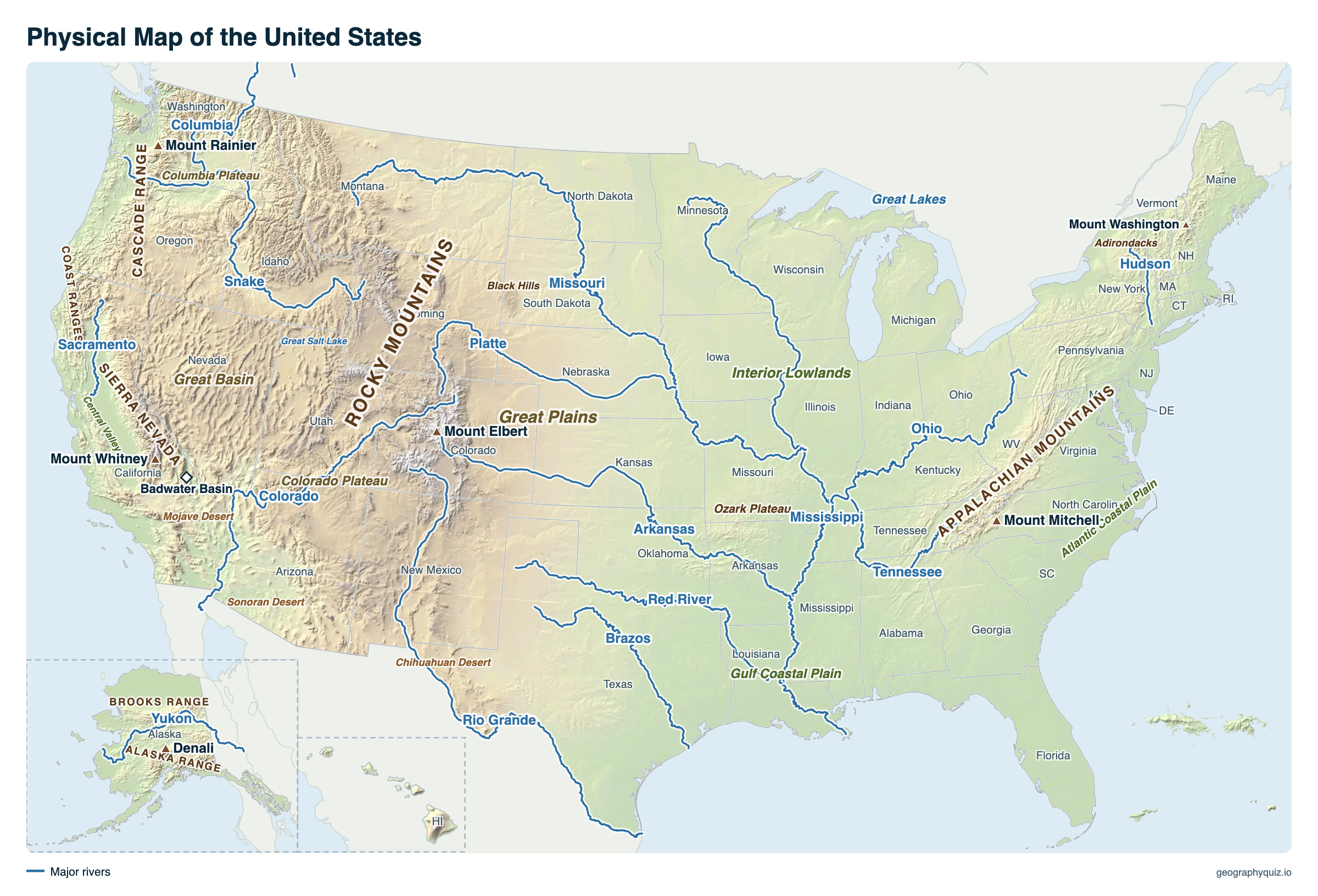
The landforms of the United States in shaded relief: the Rocky Mountains, the Sierra Nevada and Cascades in the West, the Appalachians in the East, the Great Plains and Interior Lowlands between them, the basins, plateaus and deserts, and the major rivers and lakes. Hover over or tap a peak or river for details.
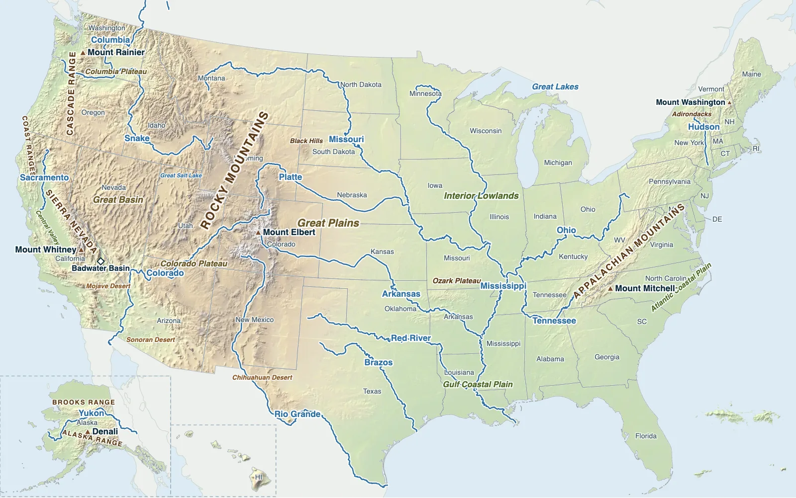
Hover over or tap a state, line or place for details. Use the key to show or hide lines.
Test yourself on this map
US Rivers Quiz · Find the major rivers on the map
Printable Physical Map of the United States
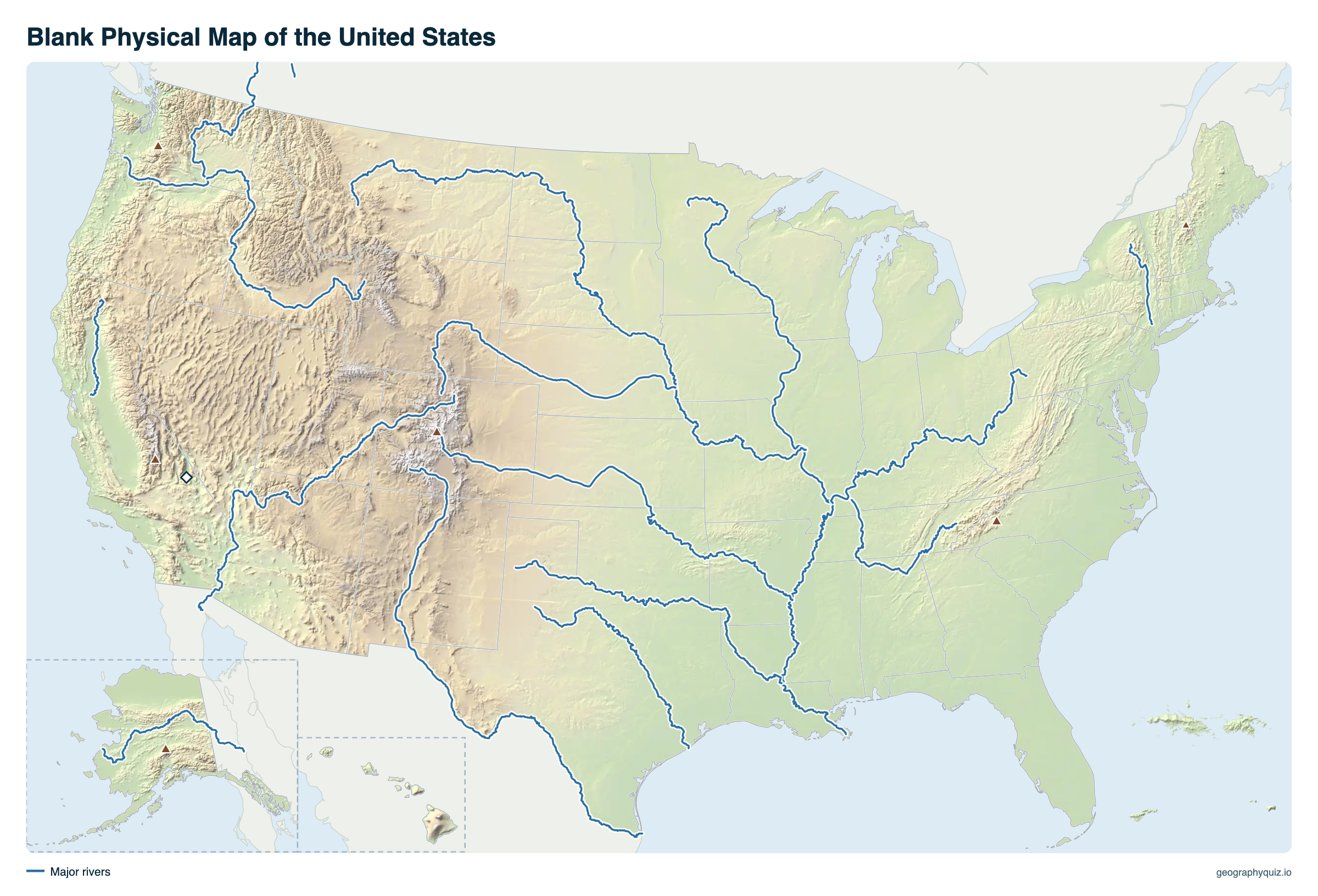
Free to print for class and home: the shaded relief map with mountain ranges, plains, plateaus, deserts, rivers and the highest peaks labeled, on one landscape A4 or US Letter page. The blank version has the same map with no names on it, for labeling in class.
Key facts
- Highest point
- Denali, Alaska, 20,310 ft (6,190 m)
- Highest in the lower 48
- Mount Whitney, California, 14,505 ft (4,421 m)
- Lowest point
- Badwater Basin, Death Valley, California, −282 ft (−86 m)
- Longest river
- Missouri, 2,540 mi (4,088 km)
- Largest lake
- Lake Superior (shared with Canada); Lake Michigan is the largest entirely in the US
- Longest mountain range
- Rocky Mountains, about 3,000 mi from New Mexico to Canada
The physical regions of the United States
Geographers divide the lower 48 states into eight major physical divisions, from east to west.
| Region | Where | Landforms |
|---|---|---|
| Atlantic Plain | The Atlantic and Gulf coasts, from Cape Cod to Texas | Low, flat coastal plain with barrier islands, marshes, Florida and the Mississippi Delta |
| Appalachian Highlands | Alabama to Maine | Old, worn-down mountains and ridges: the Blue Ridge, the Great Smoky Mountains, the Allegheny Plateau, the Piedmont |
| Laurentian Upland | Around Lake Superior, in Minnesota, Wisconsin and Michigan | Ancient rock of the Canadian Shield, lakes and forests |
| Interior Plains | From the Appalachians to the Rockies | The Interior Lowlands of the Midwest and the higher, drier Great Plains |
| Interior Highlands | Missouri, Arkansas and Oklahoma | The Ozark Plateau and the Ouachita Mountains |
| Rocky Mountain System | New Mexico to Montana and Alaska | High ranges such as the Front Range, Sawatch, Wind River, Tetons and Bitterroots |
| Intermontane Plateaus | Between the Rockies and the Pacific ranges | The Columbia Plateau, the Colorado Plateau with the Grand Canyon, and the Basin and Range with the Great Basin and the deserts |
| Pacific Mountain System | The West Coast | The Sierra Nevada, the Cascades and their volcanoes, the Coast Ranges and the Central Valley |
Highest mountains in the United States
Alaska has 17 of the 20 highest peaks in the country. These are the highest of each major range.
| Peak | Elevation | Range | State |
|---|---|---|---|
| Denali | 20,310 ft (6,190 m) | Alaska Range | Alaska |
| Mount Whitney | 14,505 ft (4,421 m) | Sierra Nevada | California |
| Mount Elbert | 14,440 ft (4,401 m) | Rocky Mountains (Sawatch Range) | Colorado |
| Mount Rainier | 14,411 ft (4,392 m) | Cascade Range | Washington |
| Mount Shasta | 14,179 ft (4,322 m) | Cascade Range | California |
| Gannett Peak | 13,804 ft (4,207 m) | Wind River Range | Wyoming |
| Grand Teton | 13,775 ft (4,199 m) | Teton Range | Wyoming |
| Kings Peak | 13,528 ft (4,123 m) | Uinta Mountains | Utah |
| Mount Mitchell | 6,684 ft (2,037 m) | Appalachian Mountains (Black Mountains) | North Carolina |
| Mount Washington | 6,288 ft (1,917 m) | White Mountains | New Hampshire |
Mountains, plains and deserts
The West is young, high and rugged. The Rocky Mountains run about 3,000 miles from New Mexico into Canada and carry the Continental Divide; west of them lie high plateaus and basins, including the Great Basin, where rivers never reach the sea, and the Mojave, Sonoran and Chihuahuan deserts. Along the Pacific, the Sierra Nevada and the volcanic Cascade Range rise above the Central Valley and the Coast Ranges. Death Valley, below sea level, is less than 90 miles from Mount Whitney.
The middle of the country is a vast plain, sloping gently from about 5,000 feet at the foot of the Rockies down to a few hundred feet along the Mississippi. The western Great Plains are dry grassland; the Interior Lowlands to the east, flattened by Ice Age glaciers, are the farm belt. In the East the Appalachians, once as high as the Rockies, have been worn down over hundreds of millions of years to rounded ridges, below 7,000 feet, with the Atlantic and Gulf coastal plains beyond.
Frequently asked questions
What is a physical map of the United States?
A map that shows the land itself rather than states and cities: mountains, hills, plains, plateaus, valleys, deserts, rivers and lakes, usually with shading or colors for elevation. This one uses shaded relief from elevation data.
What are the major landforms of the United States?
The Rocky Mountains, Sierra Nevada and Cascades in the West; the Appalachian Mountains in the East; the Great Plains and Interior Lowlands in the middle; the Great Basin, Colorado Plateau and Columbia Plateau between the western ranges; and the coastal plains along the Atlantic and the Gulf of Mexico.
What is the highest point in the United States?
Denali in Alaska, 20,310 feet (6,190 m), also the highest peak in North America. In the lower 48 states it is Mount Whitney, California, at 14,505 feet.
What is the lowest point in the United States?
Badwater Basin in Death Valley, California, 282 feet (86 m) below sea level, the lowest point in North America.
Which is older, the Appalachians or the Rockies?
The Appalachians, formed about 480 to 300 million years ago, which is why they are lower and rounded. The Rocky Mountains rose much later, mostly between about 80 and 55 million years ago.
What are the Great Plains?
The broad, dry grassland between the Mississippi lowlands and the Rocky Mountains, from Texas to Montana and into Canada, rising westward from about 1,500 to over 5,000 feet.
Sources
- Shaded relief: US Geological Survey, 3D Elevation Program (3DEP) elevation data, in the projection of our US map.
- Elevations: US Geological Survey and National Geodetic Survey (Denali: 2015 survey).
- Physical divisions: US Geological Survey, Physiographic divisions of the conterminous United States (after Fenneman and Johnson, 1946).
- State boundaries: US Census Bureau, cartographic boundary files (2024); rivers: the rivers of our US map.