US geography · interactive map
Great Plains Map
The Great Plains cover parts of 10 states: Montana, North Dakota, South Dakota, Wyoming, Nebraska, Kansas, Colorado, Oklahoma, Texas and New Mexico. They are the broad, high grassland between the Interior Lowlands and the Rocky Mountains, about 531,000 square miles in the US, and continue north into Canada. The colored areas are the Great Plains and their sections, as geologists map them; hover over or tap one for its name, or a river for its course.
- The 10 Great Plains states
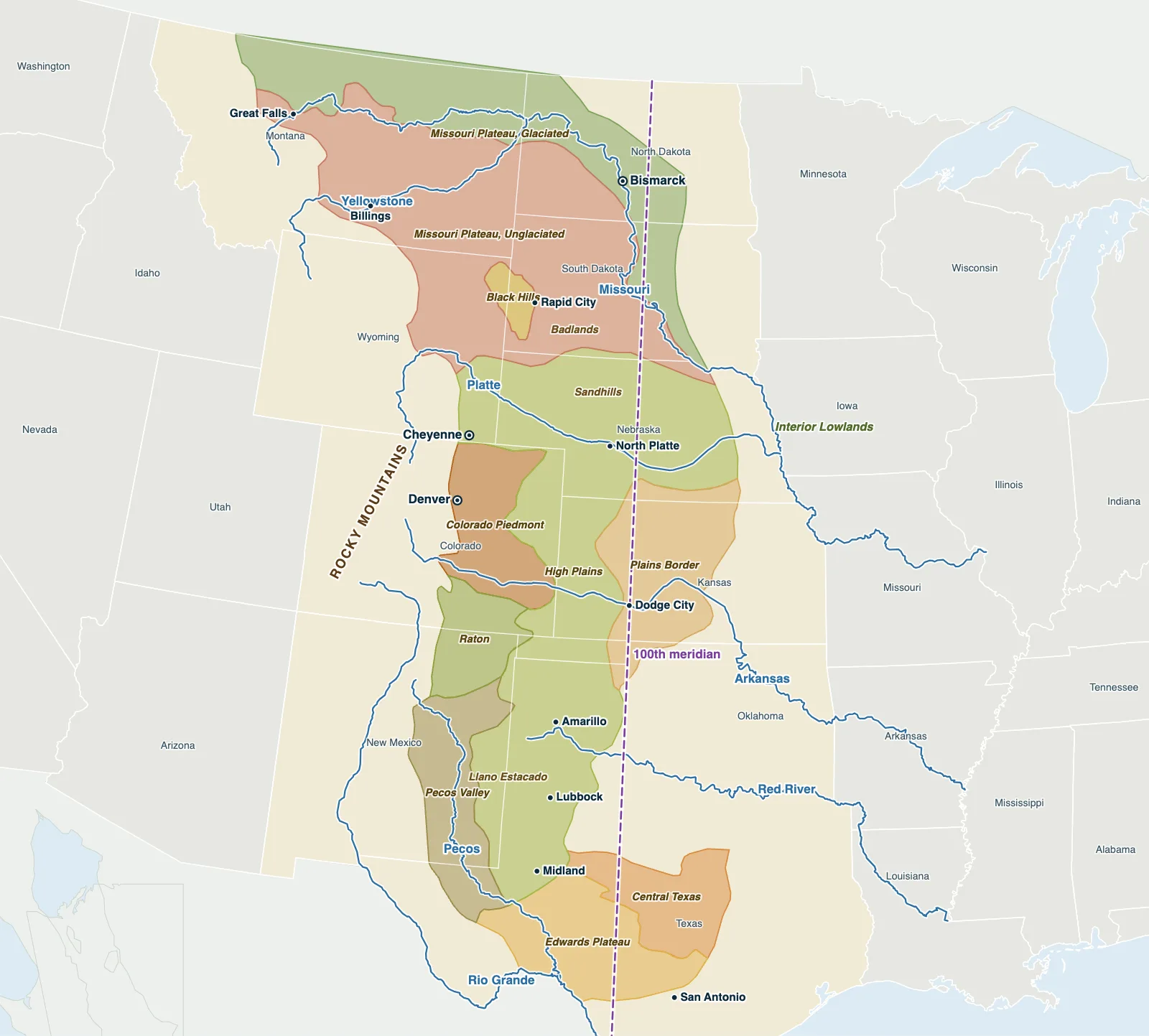
Hover over or tap a state, line or place for details. Use the key to show or hide lines.
Test yourself on this map
US States by Region · Sort the states into their regions
Printable Great Plains Map
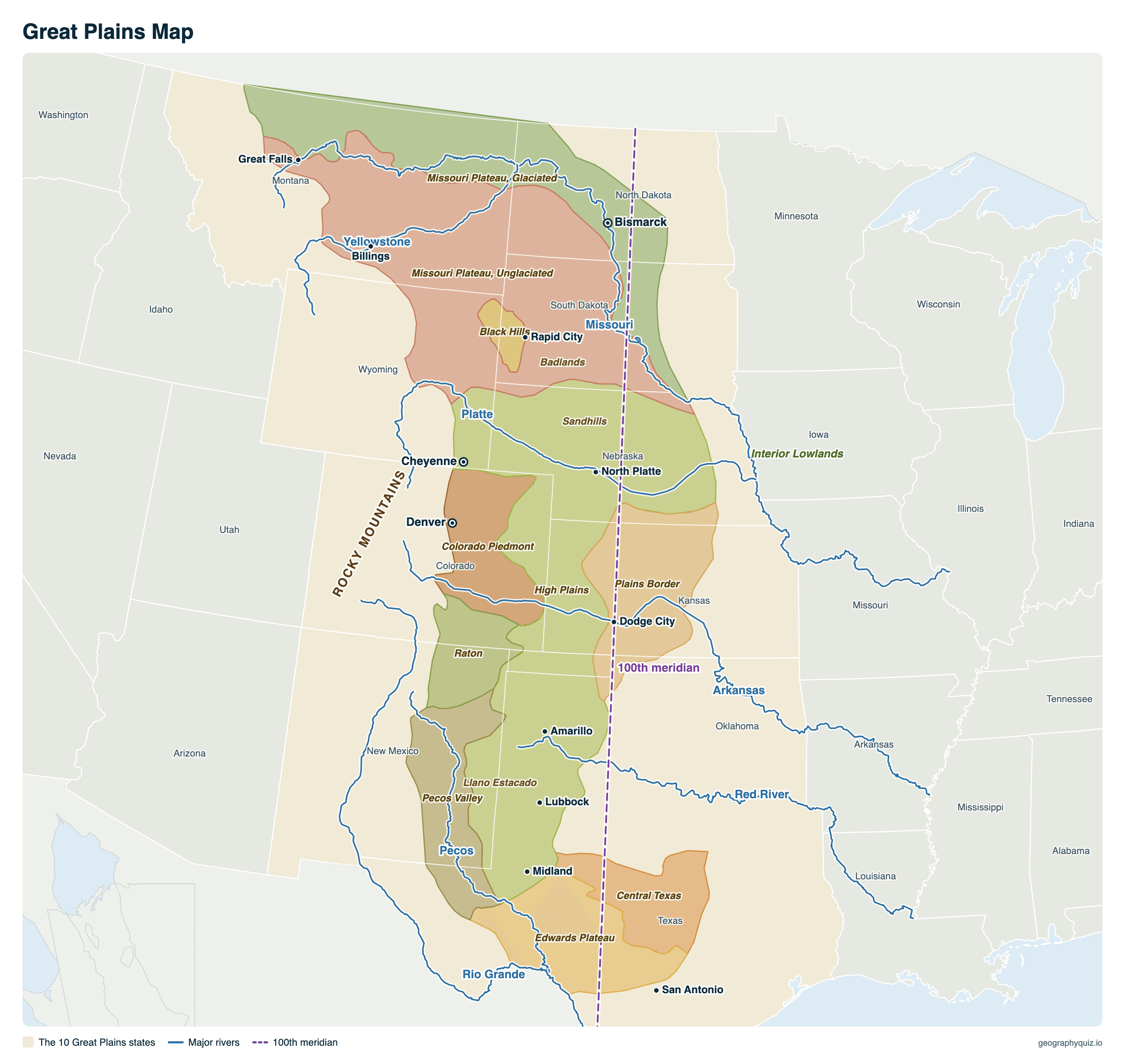
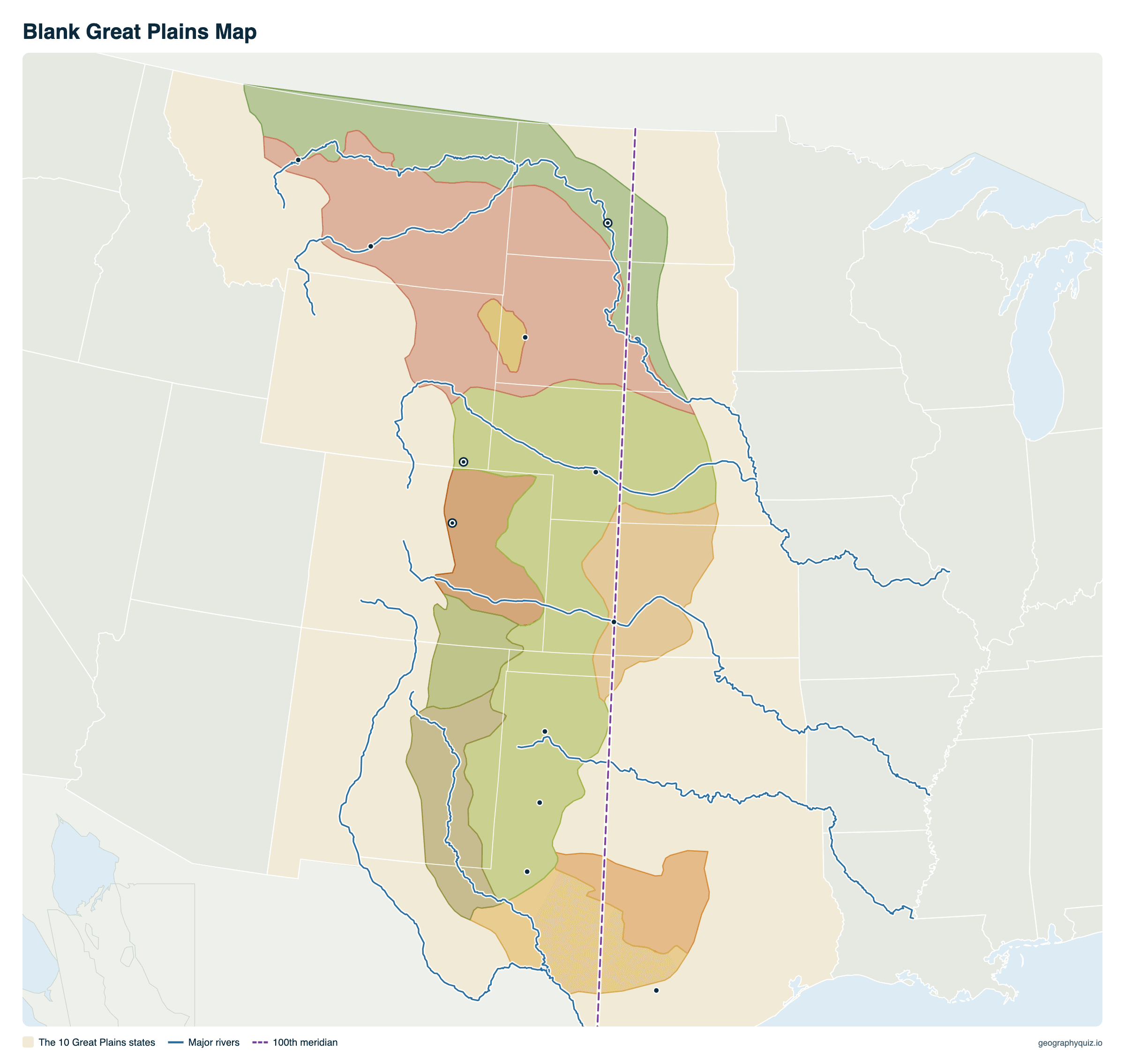
Free to print for class and home: the Great Plains and their sections, the 10 Great Plains states, the major rivers and the 100th meridian, on one landscape A4 or US Letter page. The blank version leaves out the names, so students can label the states, the regions and the rivers. The blank version has the same map with no names on it, for labeling in class.
Key facts
- Area
- About 531,000 sq mi (1.38 million km²) in the US; the Plains continue into Canada
- From – to
- The Rio Grande in Texas to the Canadian border (and on into Alberta, Saskatchewan and Manitoba)
- States
- Parts of 10: Montana, Wyoming, Colorado, New Mexico, Texas, Oklahoma, Kansas, Nebraska, South Dakota, North Dakota
- Elevation
- From about 1,500 ft in the east to 5,000–6,000 ft at the foot of the Rockies
- Rainfall
- About 12–25 inches a year, less to the west
- Largest section
- The High Plains (about 154,000 sq mi)
Sections of the Great Plains
Geologists divide the Great Plains province into sections by their landforms, from north to south. Areas are measured from the boundaries on the map.
| Section | Where | Area |
|---|---|---|
| Missouri Plateau, Glaciated | Northern Montana and the Dakotas, shaped by Ice Age glaciers | 73,000 sq mi |
| Missouri Plateau, Unglaciated | Eastern Montana and Wyoming, western Dakotas: badlands and buttes | 129,000 sq mi |
| Black Hills | Western South Dakota and northeastern Wyoming: a dome of mountains rising from the Plains | 5,000 sq mi |
| High Plains | Nebraska to the Texas Panhandle, including the flat Llano Estacado | 154,000 sq mi |
| Plains Border | Central Kansas, reaching into southern Nebraska and northern Oklahoma, where the High Plains break down to the lowlands | 40,000 sq mi |
| Colorado Piedmont | Eastern Colorado, at the foot of the Front Range | 26,000 sq mi |
| Raton | Southern Colorado and northeastern New Mexico: mesas and volcanic peaks | 17,000 sq mi |
| Pecos Valley | Eastern New Mexico and west Texas, along the Pecos River | 30,000 sq mi |
| Edwards Plateau | Central Texas: limestone Hill Country | 35,000 sq mi |
| Central Texas | Between the Edwards Plateau and the lowlands | 23,000 sq mi |
What are the Great Plains like?
The Great Plains slope gently upward from east to west, from about 1,500 feet to more than 5,000 feet where they meet the Rocky Mountains. They are drier than the farm belt to the east: west of about the 100th meridian, average rainfall drops below about 20 inches a year, and short grasses replace the tall prairie. Rivers such as the Missouri, the Platte, the Arkansas and the Red cross them on their way east.
Once the home of tens of millions of bison and of Native nations including the Lakota, Cheyenne, Comanche and Kiowa, the Plains were settled by farmers and ranchers after the Homestead Act of 1862. Plowing up the grass helped cause the Dust Bowl of the 1930s. Today the region grows much of America's wheat and cattle, watered in many places from the Ogallala Aquifer, and has some of its fastest-growing energy production.
Frequently asked questions
What states are in the Great Plains?
Parts of 10 states: Montana, Wyoming, Colorado, New Mexico, Texas, Oklahoma, Kansas, Nebraska, South Dakota and North Dakota. The Plains also extend into the Canadian provinces of Alberta, Saskatchewan and Manitoba.
Where are the Great Plains?
In the middle of North America, between the Rocky Mountains to the west and the Interior Lowlands of the Midwest to the east, from the Rio Grande in Texas north into Canada.
How big are the Great Plains?
The US part of the Great Plains province covers about 531,000 square miles (1.38 million km²), about 17% of the lower 48 states.
What is the largest plain in the US?
The Great Plains, about 531,000 square miles in the US alone. Together with the Interior Lowlands to the east, they form the Interior Plains, the vast lowland that fills the middle of North America from the Appalachians to the Rockies.
Why are the Great Plains so flat?
They are built of layers of sedimentary rock that have lain almost undisturbed for millions of years: mud and sand laid down on the floor of a shallow sea that covered the middle of the continent, later buried under a thick apron of sand and gravel washed east from the rising Rocky Mountains. Rivers have cut valleys into it, but the land between them stays smooth and gently sloping.
Which came first, the Rocky Mountains or the Great Plains?
The rocks under the Plains are older: most were laid down in that inland sea before the Rockies rose, about 80 to 55 million years ago. The surface of the High Plains came later, built over the last 20 million years or so from sand and gravel eroded off the new mountains.
What is the difference between the High Plains and the Great Plains?
The High Plains are one section of the Great Plains: the highest and flattest part, from Nebraska and Wyoming south through eastern Colorado and western Kansas to the Llano Estacado of the Texas Panhandle and eastern New Mexico. The Great Plains also include the Missouri Plateau to the north, the Edwards Plateau to the south and other sections.
What is the difference between the Great Plains and the prairie?
The prairie is the grassland; the Great Plains are the landform. The eastern Plains and the Interior Lowlands were tall-grass prairie; the drier western Plains are short-grass prairie or steppe.
Why is the 100th meridian important?
It runs roughly where the Plains become too dry for farming without irrigation: average rainfall to the west is usually below about 20 inches a year. Explorer John Wesley Powell called it the line where the arid West begins.
What caused the Dust Bowl?
Years of drought in the 1930s on Plains land that had been plowed up, removing the deep-rooted grasses that held the soil. Winds blew the dry topsoil away in huge dust storms, hitting the Oklahoma and Texas panhandles, western Kansas and nearby areas hardest.
Sources
- Great Plains province and sections: US Geological Survey, Physiographic divisions of the conterminous United States (Fenneman and Johnson, 1946). Rivers: US Geological Survey.
- State boundaries: US Census Bureau, cartographic boundary files (2024); city locations: US Census Bureau Gazetteer.
- Rainfall and history: National Oceanic and Atmospheric Administration (US climate normals) and National Park Service.