Interactive map
US Time Zone Map
The six time zones of the 50 states, with the time in each right now. Tap a state for its zone; 13 states are split between two. Puerto Rico, Guam and the other territories have three more zones of their own.
- Eastern
- Central
- Mountain
- Pacific
- Alaska
- Hawaii-AleutianHawaii
- Arizona
Tap or click a state to see its time zone and the time there now.
Printable US time zone map
Free to print: the six time zones with their names, UTC offsets and state borders, on one landscape A4 or US Letter page.
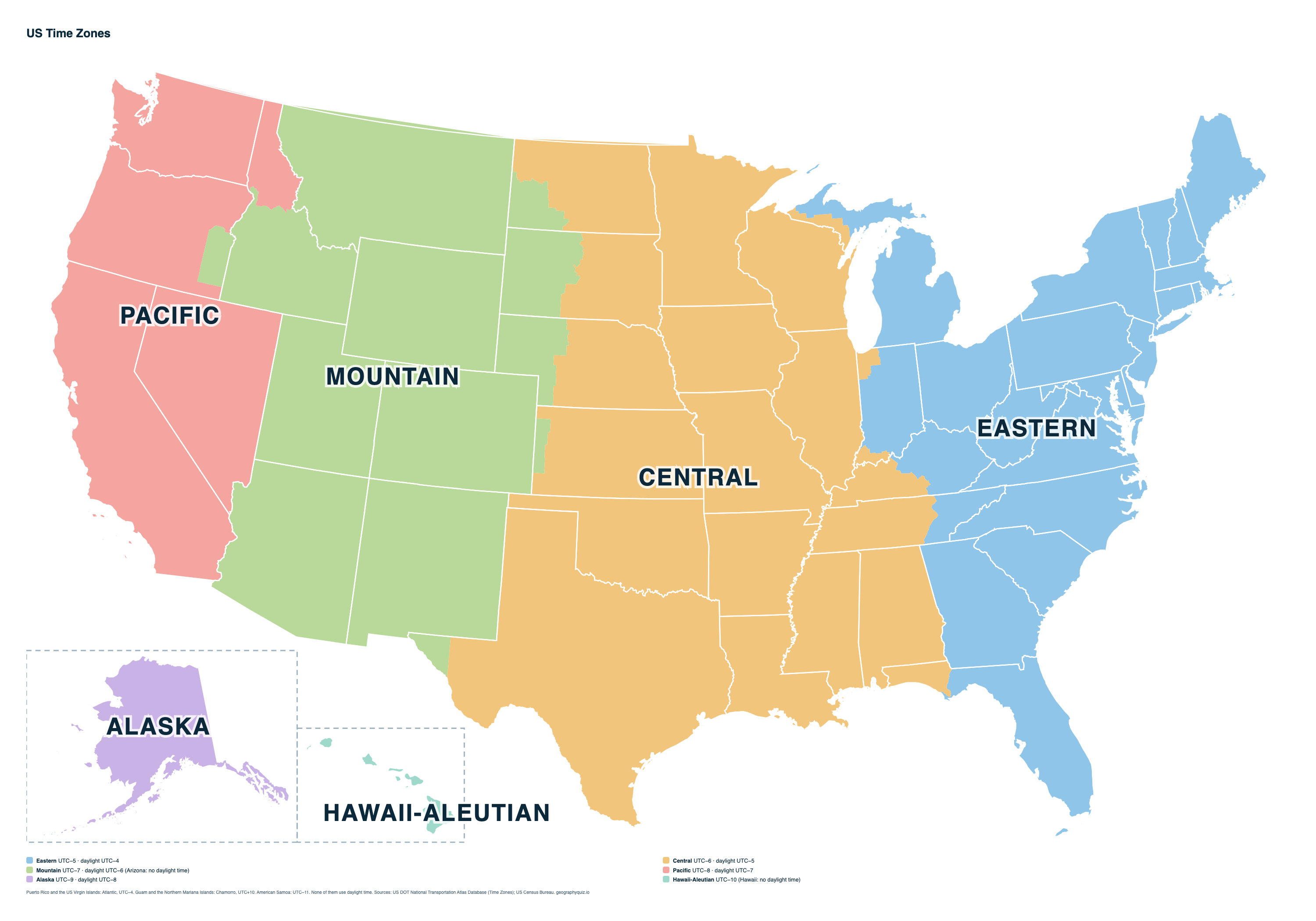
Key facts
- Time zones in the 50 states
- 6
- With the territories
- 9
- States in two time zones
- 13
- Most states
- Eastern (23, with Washington, D.C.)
- Daylight saving time
- Second Sunday in March to first Sunday in November
- No daylight saving
- Arizona (except the Navajo Nation), Hawaii and the territories
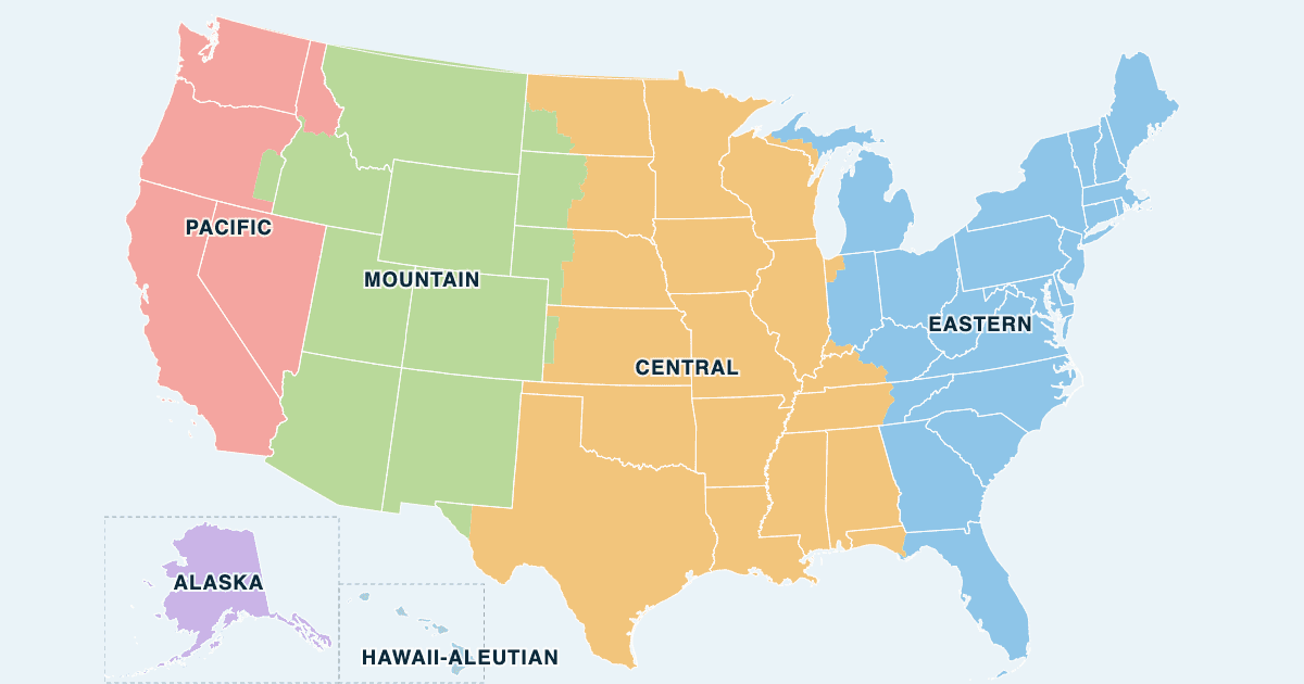
The US time zones
From east to west, each zone is an hour behind the one before. The 50 states use six; the territories add three.
| Zone | Now | Standard time | Daylight time | Daylight saving | Main cities |
|---|---|---|---|---|---|
| Eastern | UTC−5 | UTC−4 | Yes | New York, Washington, Atlanta, Miami, Detroit | |
| Central | UTC−6 | UTC−5 | Yes | Chicago, Houston, Dallas, New Orleans, Minneapolis | |
| Mountain | UTC−7 | UTC−6 | Yes, except most of Arizona | Denver, Phoenix, Salt Lake City, Albuquerque, Boise | |
| Pacific | UTC−8 | UTC−7 | Yes | Los Angeles, San Francisco, Seattle, Las Vegas, Portland | |
| Alaska | UTC−9 | UTC−8 | Yes | Anchorage, Fairbanks, Juneau | |
| Hawaii-Aleutian | UTC−10 | UTC−9 (Aleutian Islands only) | Aleutian Islands only, not Hawaii | Honolulu, Hilo, Adak | |
| Atlantic | UTC−4 | – | No | San Juan (Puerto Rico), Charlotte Amalie (US Virgin Islands) | |
| Samoa | UTC−11 | – | No | Pago Pago (American Samoa) | |
| Chamorro | UTC+10 | – | No | Hagåtña (Guam), Saipan (Northern Mariana Islands) |
Which states are in each time zone
States split between two zones appear under both.
| Zone | States |
|---|---|
| Eastern | Connecticut, Delaware, District of Columbia, Florida, Georgia, Indiana, Kentucky, Maine, Maryland, Massachusetts, Michigan, New Hampshire, New Jersey, New York, North Carolina, Ohio, Pennsylvania, Rhode Island, South Carolina, Tennessee, Vermont, Virginia, West Virginia |
| Central | Alabama, Arkansas, Florida, Illinois, Indiana, Iowa, Kansas, Kentucky, Louisiana, Michigan, Minnesota, Mississippi, Missouri, Nebraska, North Dakota, Oklahoma, South Dakota, Tennessee, Texas, Wisconsin |
| Mountain | Arizona, Colorado, Idaho, Kansas, Montana, Nebraska, New Mexico, North Dakota, Oregon, South Dakota, Texas, Utah, Wyoming |
| Pacific | California, Idaho, Nevada, Oregon, Washington |
| Alaska | Alaska |
| Hawaii-Aleutian | Alaska, Hawaii |
The 13 states in two time zones
| State | Main zone | Also |
|---|---|---|
| Alaska | Alaska (nearly all of the land) | Hawaii-Aleutian (under 1%) |
| Florida | Eastern (86% of the land) | Central (14%) |
| Idaho | Mountain (76% of the land) | Pacific (24%) |
| Indiana | Eastern (86% of the land) | Central (14%) |
| Kansas | Central (95% of the land) | Mountain (5%) |
| Kentucky | Eastern (61% of the land) | Central (39%) |
| Michigan | Eastern (93% of the land) | Central (7%) |
| Nebraska | Central (69% of the land) | Mountain (31%) |
| North Dakota | Central (82% of the land) | Mountain (18%) |
| Oregon | Pacific (92% of the land) | Mountain (8%) |
| South Dakota | Central (57% of the land) | Mountain (43%) |
| Tennessee | Central (71% of the land) | Eastern (29%) |
| Texas | Central (98% of the land) | Mountain (2%) |
Shares are of each state's land area, not its people: most of Texas's Mountain time area, for example, is the El Paso region.
Daylight saving time
Clocks go forward one hour at 2:00 a.m. local time on the second Sunday in March and back on the first Sunday in November. Arizona (except the Navajo Nation), Hawaii, Puerto Rico, the US Virgin Islands, Guam, the Northern Mariana Islands and American Samoa stay on standard time all year, so in summer Arizona shares the Pacific zone's clock time.
Sources
- Time zone boundaries: US Department of Transportation, Bureau of Transportation Statistics, National Transportation Atlas Database, Time Zones (the boundaries set in 49 CFR Part 71).
- State boundaries: US Census Bureau, cartographic boundary files (2024).
- Daylight saving time: 15 U.S.C. 260a (Uniform Time Act, as amended by the Energy Policy Act of 2005).