Interactive map
North Carolina Map
Every county, city and town in North Carolina on one zoomable map, with interstates, US highways, rivers and lakes. Switch on towns and counties above the map and zoom in for every name; tap a county to see its seat, population and largest towns.
Loading the map…
Printable maps of North Carolina
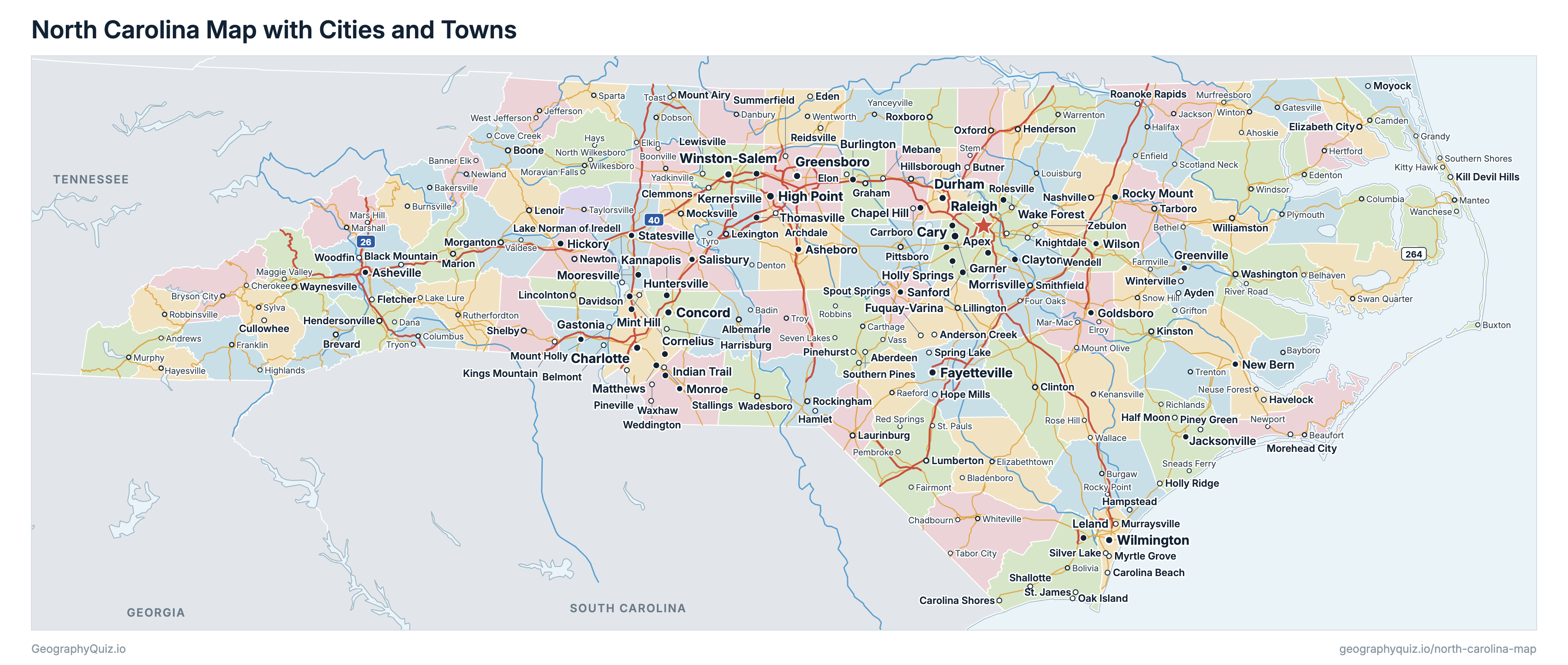
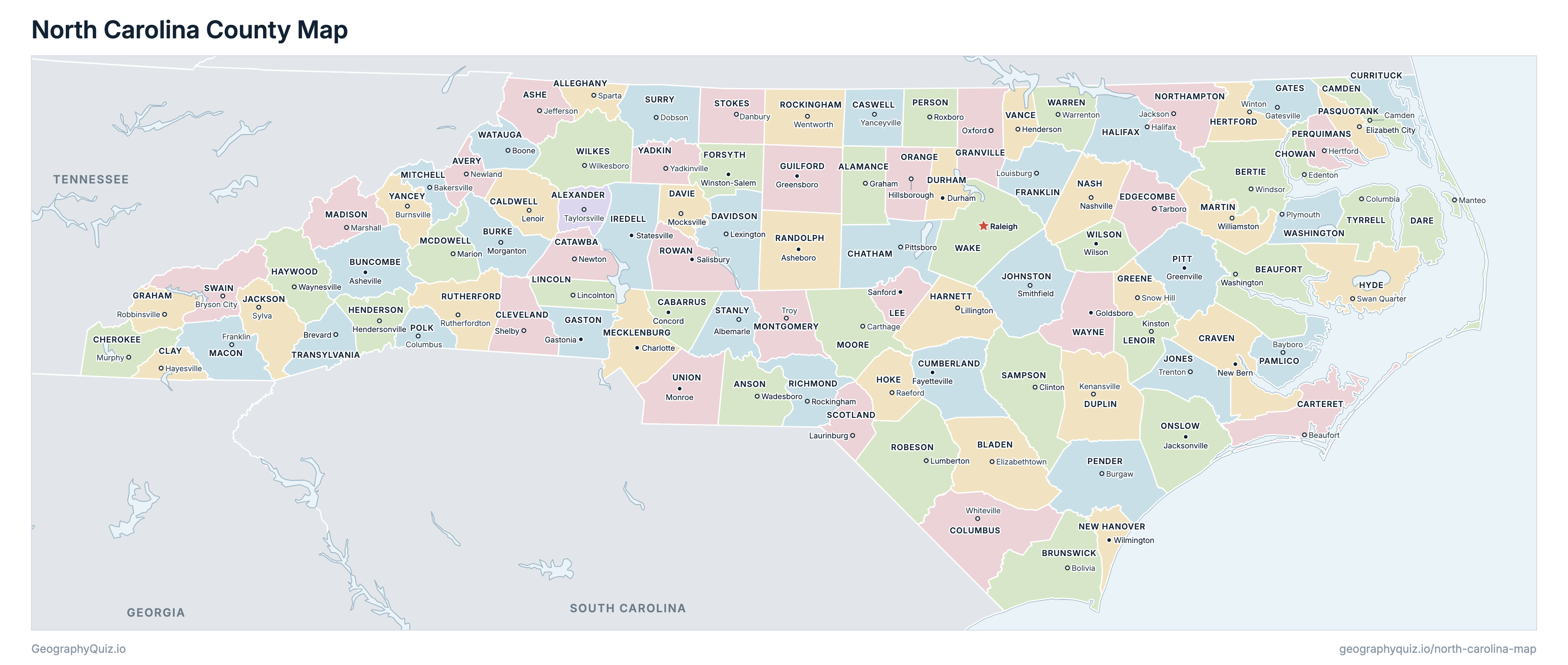
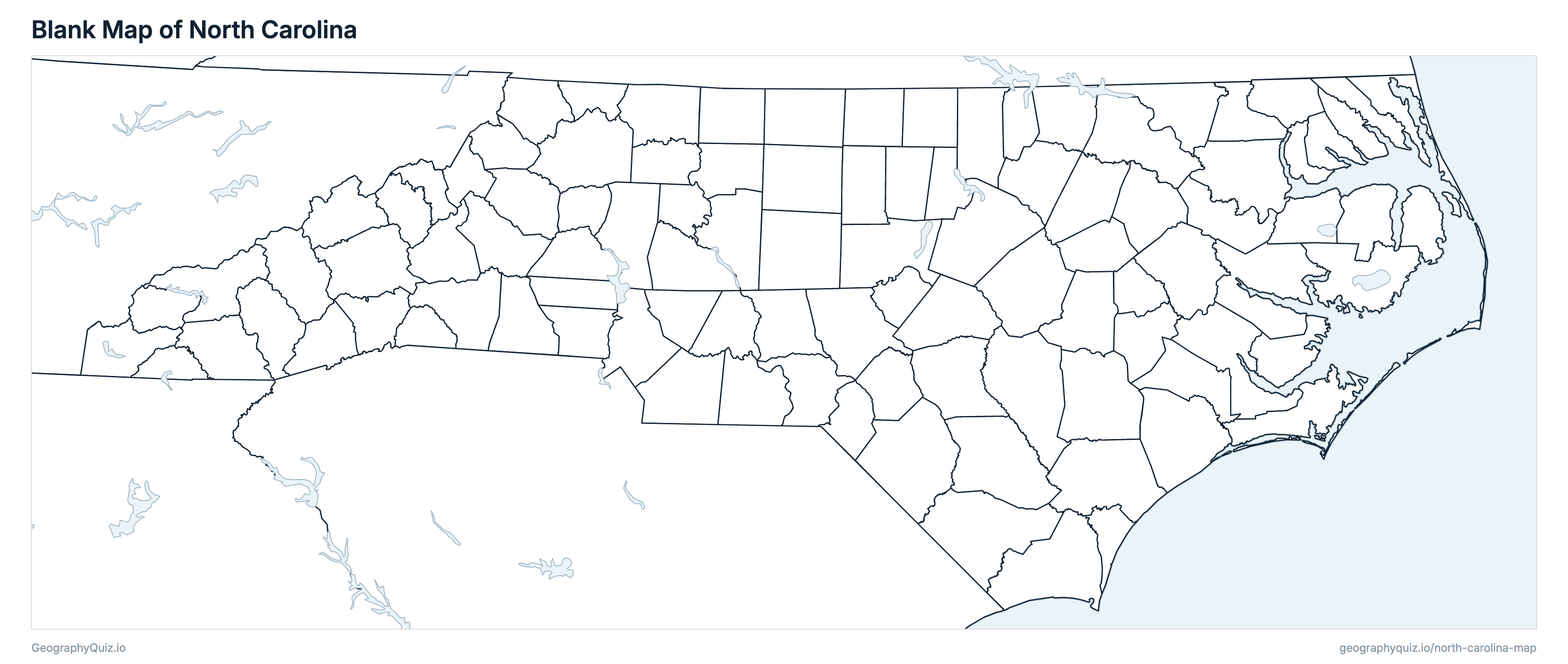
Free to print for class and home: North Carolina with its cities and towns, a county map with every county and county seat, and a blank outline map. PDFs fit one A4 or US Letter page.
North Carolina map with cities
North Carolina county map
About North Carolina
North Carolina has 100 counties, 77 cities, 451 towns, 21 villages and 223 Census-designated communities, and about 11,197,968 people (2025 estimate) on 125,936 km² (48,624 sq mi) of land. The capital is Raleigh; the largest city is Charlotte, with 964,784 people. It borders Georgia, South Carolina, Tennessee and Virginia.
Wake County is the most populous county (1,257,235 people) and Tyrrell County the least (3,537); Robeson County is the largest by land area (2,453 km²) and Chowan County the smallest (447 km²).
Largest cities in North Carolina
The 25 most populous cities and towns. All 772 are on the map above: switch on Towns and zoom in to see them.
| # | City | County | Population |
|---|---|---|---|
| 1 | Charlotte | Mecklenburg County | 964,784 |
| 2 | Raleigh | Wake County | 506,306 |
| 3 | Greensboro | Guilford County | 308,667 |
| 4 | Durham | Durham County | 305,561 |
| 5 | Winston-Salem | Forsyth County | 257,271 |
| 6 | Fayetteville | Cumberland County | 209,120 |
| 7 | Cary | Wake County | 183,582 |
| 8 | Wilmington | New Hanover County | 126,809 |
| 9 | High Point | Guilford County | 120,571 |
| 10 | Concord | Cabarrus County | 114,598 |
| 11 | Greenville | Pitt County | 96,443 |
| 12 | Asheville | Buncombe County | 93,523 |
| 13 | Gastonia | Gaston County | 87,067 |
| 14 | Apex | Wake County | 80,419 |
| 15 | Jacksonville | Onslow County | 72,732 |
| 16 | Huntersville | Mecklenburg County | 68,535 |
| 17 | Chapel Hill | Orange County | 63,565 |
| 18 | Kannapolis | Cabarrus County | 61,708 |
| 19 | Burlington | Alamance County | 61,496 |
| 20 | Wake Forest | Wake County | 58,147 |
| 21 | Mooresville | Iredell County | 55,842 |
| 22 | Rocky Mount | Nash County | 55,120 |
| 23 | Holly Springs | Wake County | 50,288 |
| 24 | Wilson | Wilson County | 49,572 |
| 25 | Fuquay-Varina | Wake County | 48,536 |
Populations are US Census Bureau estimates for July 2025, within city or town limits.
Counties of North Carolina
All 100 counties with their county seats. Select one to show it on the map.
| Graham | 186,177 | 1,097 | |
| Taylorsville | 36,958 | 673 | |
| Sparta | 11,479 | 608 | |
| Wadesboro | 21,758 | 1,376 | |
| Jefferson | 27,514 | 1,104 | |
| Newland | 18,110 | 641 | |
| Washington | 44,670 | 2,157 | |
| Windsor | 17,086 | 1,811 | |
| Elizabethtown | 30,007 | 2,266 | |
| Bolivia | 174,702 | 2,202 | |
| Asheville | 277,417 | 1,700 | |
| Morganton | 88,655 | 1,311 | |
| Concord | 249,725 | 936 | |
| Lenoir | 81,105 | 1,222 | |
| Camden | 11,315 | 622 | |
| Beaufort | 70,469 | 1,315 | |
| Yanceyville | 22,563 | 1,102 | |
| Newton | 170,172 | 1,040 | |
| Pittsboro | 85,111 | 1,765 | |
| Murphy | 30,830 | 1,180 | |
| Edenton | 14,082 | 447 | |
| Hayesville | 12,239 | 557 | |
| Shelby | 103,325 | 1,202 | |
| Whiteville | 50,487 | 2,430 | |
| New Bern | 105,025 | 1,830 | |
| Fayetteville | 338,473 | 1,690 | |
| Currituck | 33,158 | 678 | |
| Manteo | 38,245 | 993 | |
| Lexington | 180,182 | 1,433 | |
| Mocksville | 45,855 | 683 | |
| Kenansville | 51,571 | 2,110 | |
| Durham | 347,240 | 745 | |
| Tarboro | 49,121 | 1,309 | |
| Winston-Salem | 401,718 | 1,056 | |
| Louisburg | 82,037 | 1,274 | |
| Gastonia | 246,558 | 921 | |
| Gatesville | 10,234 | 882 | |
| Robbinsville | 8,190 | 756 | |
| Oxford | 61,421 | 1,378 | |
| Snow Hill | 20,700 | 691 | |
| Greensboro and High Point | 562,234 | 1,673 | |
| Halifax | 46,534 | 1,874 | |
| Lillington | 150,137 | 1,541 | |
| Waynesville | 63,369 | 1,434 | |
| Hendersonville | 122,375 | 966 | |
| Winton | 19,015 | 915 | |
| Raeford | 56,939 | 1,010 | |
| Swan Quarter | 4,554 | 1,586 | |
| Statesville | 211,798 | 1,488 | |
| Sylva | 45,039 | 1,272 | |
| Smithfield | 256,448 | 2,051 | |
| Trenton | 9,575 | 1,221 | |
| Sanford | 70,258 | 661 | |
| Kinston | 55,837 | 1,034 | |
| Lincolnton | 98,654 | 766 | |
| Franklin | 39,232 | 1,335 | |
| Marshall | 22,553 | 1,164 | |
| Williamston | 21,601 | 1,182 | |
| Marion | 45,198 | 1,139 | |
| Charlotte | 1,233,383 | 1,356 | |
| Bakersville | 15,062 | 573 | |
| Troy | 26,403 | 1,273 | |
| Carthage | 110,619 | 1,807 | |
| Nashville | 99,365 | 1,400 | |
| Wilmington | 245,959 | 498 | |
| Jackson | 16,491 | 1,390 | |
| Jacksonville | 217,175 | 1,974 | |
| Hillsborough | 152,498 | 1,030 | |
| Bayboro | 12,758 | 872 | |
| Elizabeth City | 42,201 | 588 | |
| Burgaw | 72,111 | 2,257 | |
| Hertford | 13,490 | 640 | |
| Roxboro | 40,636 | 1,016 | |
| Greenville | 182,936 | 1,690 | |
| Columbus | 20,533 | 616 | |
| Asheboro | 149,516 | 2,026 | |
| Rockingham | 42,041 | 1,227 | |
| Lumberton | 119,941 | 2,453 | |
| Wentworth | 94,195 | 1,465 | |
| Salisbury | 155,096 | 1,325 | |
| Rutherfordton | 65,745 | 1,464 | |
| Clinton | 61,504 | 2,450 | |
| Laurinburg | 33,322 | 827 | |
| Albemarle | 68,830 | 1,023 | |
| Danbury | 46,126 | 1,164 | |
| Dobson | 72,287 | 1,380 | |
| Bryson City | 14,024 | 1,367 | |
| Brevard | 34,211 | 980 | |
| Columbia | 3,537 | 1,012 | |
| Monroe | 267,674 | 1,639 | |
| Henderson | 42,638 | 654 | |
| Raleigh | 1,257,235 | 2,162 | |
| Warrenton | 18,898 | 1,112 | |
| Plymouth | 10,638 | 897 | |
| Boone | 54,786 | 809 | |
| Goldsboro | 122,278 | 1,435 | |
| Wilkesboro | 66,233 | 1,952 | |
| Wilson | 81,150 | 952 | |
| Yadkinville | 38,325 | 867 | |
| Burnsville | 19,084 | 810 |
Practise US geography
Sources
- Counties, state borders, city and town locations and highways: US Census Bureau cartographic boundary files, Gazetteer files and TIGER/Line roads (2023).
- Populations: US Census Bureau Population Estimates, Vintage 2025; Census-designated communities: 2020 Census.
- County seats and founding years: National Association of Counties (NACo) County Explorer.