Interactive map
Equator Map
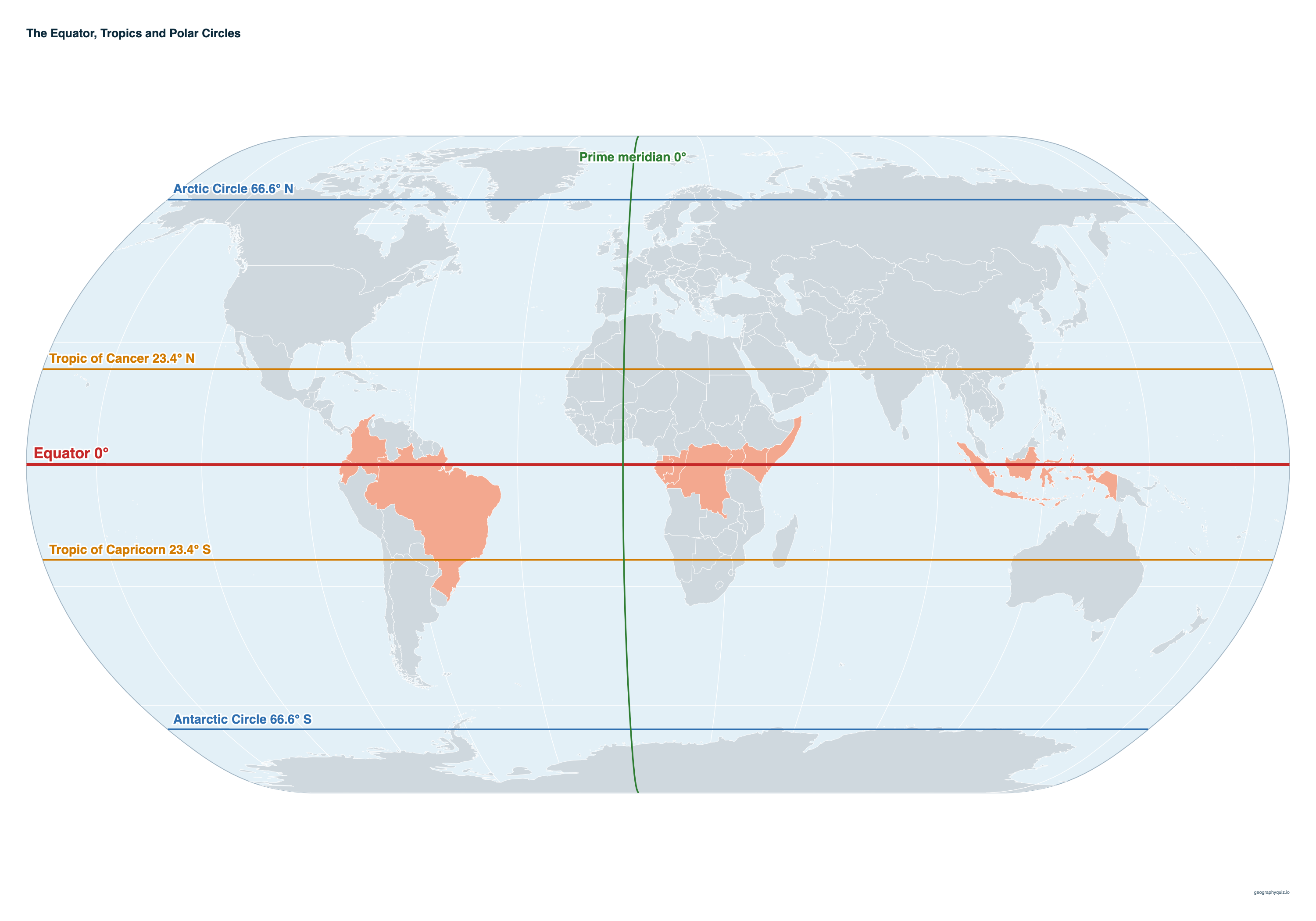
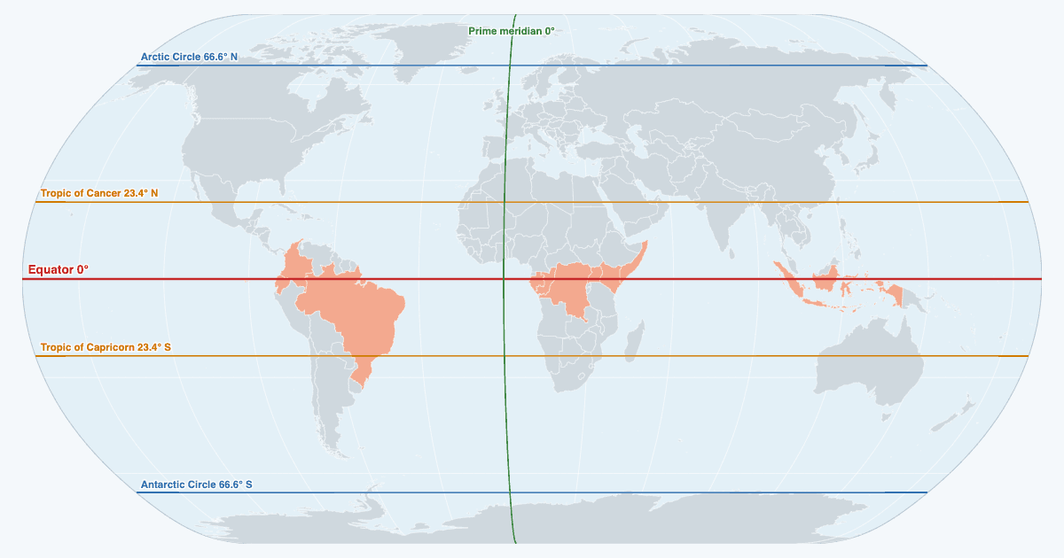
The Equator is the line of 0° latitude around the middle of the Earth, halfway between the North and South poles. It splits the world into the Northern and Southern hemispheres and passes through 13 countries. Switch to the tropics, the polar circles or the prime meridian to see the countries each one crosses, and tap a country for its hemispheres.
The Equator crosses 13 countries. Drag the globe to turn it; tap any country for its hemispheres and the lines that cross it.
Printable equator map
Free to print: the world with the Equator, the tropics, the polar circles and the prime meridian labelled, on one landscape A4 or US Letter page.
Key facts
- Latitude
- 0°
- Length
- 40,075 km (24,901 mi), the longest line of latitude
- Countries it passes through
- 13: on land in 11, through the waters of the Maldives and Kiribati
- Over land
- 8,572 km (21% of the line)
- Longest stretch
- Brazil, 2,215 km
- Oceans
- Atlantic, Indian and Pacific
- Continents
- South America, Africa, Asia and Oceania
The 13 countries on the Equator
From the prime meridian eastwards. The line crosses land in 10 of them, an islet in São Tomé and Príncipe, and only the sea in the Maldives and Kiribati.
| Country | Land on the line | Enters → leaves | What it crosses |
|---|---|---|---|
| São Tomé and Príncipe | An islet | – | Only Ilhéu das Rolas, an islet off the south of São Tomé island, where a marker shows the line. |
| Gabon | 510 km (317 mi) | 9.34° E → 13.92° E | About 45 km south of Libreville, the capital, through rainforest; Lopé National Park lies just south of the line. |
| Republic of the Congo | 427 km (265 mi) | 13.92° E → 17.76° E | Through the swamp forests of the Cuvette; the town of Makoua sits almost exactly on the line. |
| Democratic Republic of the Congo | 1,331 km (827 mi) | 17.76° E → 29.71° E | Across the Congo Basin rainforest. Mbandaka, capital of Équateur province (named after the line), is about 5 km north of it. |
| Uganda | 468 km (291 mi) | 29.71° E → 33.92° E | Just south of Kampala and across Lake Victoria; markers stand on the Kampala–Masaka road at Kayabwe. |
| Kenya | 785 km (488 mi) | 33.92° E → 40.97° E | Past the north side of Mount Kenya and through Nanyuki, then across the dry north-east to Somalia. |
| Somalia | 214 km (133 mi) | 40.97° E → 42.89° E | Through the far south, a short way north of Kismayo, before the line heads out into the Indian Ocean. |
| Maldives | Water only | – | No land: the line runs through the Equatorial Channel between Huvadhu Atoll and Fuvahmulah. |
| Indonesia | 1,465 km (910 mi), 10 stretches | 98.31° E → 129.37° E | Sumatra, the Riau and Lingga islands, Borneo (through Pontianak, with its Equator Monument), Sulawesi and Halmahera. |
| Kiribati | Water only | – | No land: the line passes through the Gilbert Islands between Aranuka and Nonouti atolls. |
| Ecuador | 550 km (342 mi), 2 stretches | 91.60° W → 75.53° W | The country is named after the line. It crosses Isabela Island in the Galápagos, then the Andes north of Quito, where the south slope of Cayambe volcano (4,690 m) is the highest point on the Equator. |
| Colombia | 607 km (377 mi) | 75.53° W → 70.07° W | A short stretch through the Amazon rainforest in the south of the country. |
| Brazil | 2,215 km (1,376 mi), 5 stretches | 70.07° W → 49.37° W | The longest stretch: Amazonas, Roraima, Pará and Amapá, reaching the Atlantic at the mouth of the Amazon. In Macapá the halfway line of the Zerão stadium is drawn on it. |
Measured on the WGS-84 ellipsoid; lakes inside a country count as its land. Figures can be off by a few kilometres.
Does the Equator pass through…?
Not through any of these. They are the countries the Equator only just misses, and the ones people most often ask about, from nearest to farthest.
| Country | Hemisphere | Distance from the Equator |
|---|---|---|
| Peru | Southern | 3 km (2 mi) south |
| Nauru | Southern | 54 km (34 mi) south |
| Venezuela | Northern | 72 km (45 mi) north |
| Malaysia | Northern | 94 km (58 mi) north |
| Micronesia | Northern | 102 km (63 mi) north |
| Tanzania | Southern | 109 km (68 mi) south |
| Rwanda | Southern | 117 km (73 mi) south |
| Guyana | Northern | 131 km (81 mi) north |
| Singapore | Northern | 140 km (87 mi) north |
| Papua New Guinea | Southern | 149 km (93 mi) south |
| Cameroon | Northern | 183 km (114 mi) north |
| Suriname | Northern | 203 km (126 mi) north |
| Nigeria | Northern | 472 km (293 mi) north |
| Philippines | Northern | 515 km (320 mi) north |
| Thailand | Northern | 623 km (387 mi) north |
| Sri Lanka | Northern | 655 km (407 mi) north |
| India | Northern | 746 km (464 mi) north |
| Australia | Southern | 1,022 km (635 mi) south |
| Mexico | Northern | 1,609 km (1,000 mi) north |
| China | Northern | 1,745 km (1,084 mi) north |
| United States | Northern | 2,091 km (1,299 mi) north |
| Egypt | Northern | 2,433 km (1,512 mi) north |
| South Africa | Southern | 2,448 km (1,521 mi) south |
Tropic of Cancer
At 23°26′09″ N (23.44°), the furthest north the Sun is ever directly overhead, at the June solstice. It is 36,789 km long and crosses 18 countries and territories; it only clips the northern tip of Chad.
| Country | Land on the line | Enters → leaves |
|---|---|---|
| Niger | 51 km (32 mi) | 11.83° E → 12.33° E |
| Libya | 1,287 km (800 mi), 2 stretches | 12.33° E → 24.98° E |
| Chad | 5 km (3 mi) | 15.95° E → 16.00° E |
| Egypt | 1,078 km (670 mi) | 24.98° E → 35.53° E |
| Saudi Arabia | 1,379 km (857 mi) | 38.64° E → 52.13° E |
| United Arab Emirates | 330 km (205 mi) | 52.13° E → 55.36° E |
| Oman | 352 km (219 mi) | 55.36° E → 58.80° E |
| India | 2,254 km (1,401 mi), 4 stretches | 68.43° E → 93.40° E |
| Bangladesh | 288 km (179 mi), 4 stretches | 88.76° E → 92.30° E |
| Myanmar | 560 km (348 mi) | 93.40° E → 98.88° E |
| China | 1,856 km (1,153 mi), 2 stretches | 98.88° E → 117.14° E |
| Taiwan | 137 km (85 mi), 2 stretches | 120.01° E → 121.48° E |
| Mexico | 984 km (611 mi), 2 stretches | 110.24° W → 97.76° W |
| Bahamas | 12 km (7 mi), 2 stretches | 75.64° W → 75.18° W |
| Western Sahara (disputed) | 400 km (249 mi) | 15.99° W → 12.07° W |
| Mauritania | 578 km (359 mi) | 12.07° W → 6.41° W |
| Mali | 407 km (253 mi) | 6.41° W → 2.42° W |
| Algeria | 1,457 km (905 mi) | 2.42° W → 11.83° E |
Tropic of Capricorn
At 23°26′09″ S, where the Sun is overhead at the December solstice. It crosses 10 countries, with the longest stretch in Australia.
| Country | Land on the line | Enters → leaves |
|---|---|---|
| Namibia | 566 km (352 mi) | 14.44° E → 19.98° E |
| Botswana | 749 km (465 mi) | 19.98° E → 27.31° E |
| South Africa | 430 km (267 mi) | 27.31° E → 31.52° E |
| Mozambique | 400 km (249 mi) | 31.52° E → 35.44° E |
| Madagascar | 402 km (250 mi) | 43.74° E → 47.67° E |
| Australia | 3,788 km (2,354 mi) | 113.77° E → 150.84° E |
| Chile | 351 km (218 mi) | 70.59° W → 67.15° W |
| Argentina | 586 km (364 mi) | 67.15° W → 61.42° W |
| Paraguay | 602 km (374 mi) | 61.42° W → 55.53° W |
| Brazil | 1,071 km (665 mi) | 55.53° W → 45.04° W |
The tropics follow the tilt of Earth's axis, which changes slowly: they are moving towards the Equator by about 15 m a year. Positions here are for 2026.
Arctic Circle and Antarctic Circle
At 66°33′51″ N and S. North of the Arctic Circle the Sun stays up for at least one full day in June and does not rise for at least one day in December; south of the Antarctic Circle it is the other way round. The Arctic Circle crosses 7 countries and territories; the Antarctic Circle crosses only Antarctica. Iceland lies just south of the Arctic Circle except for the island of Grímsey, which it crosses.
| Country | Land on the line | Enters → leaves |
|---|---|---|
| Norway | 104 km (65 mi), 2 stretches | 13.21° E → 15.59° E |
| Sweden | 368 km (229 mi) | 15.59° E → 23.88° E |
| Finland | 246 km (153 mi) | 23.88° E → 29.42° E |
| Russia | 6,747 km (4,192 mi), 10 stretches | 180.00° W → 180.00° E |
| United States | 908 km (564 mi), 4 stretches | 164.66° W → 141.00° W |
| Canada | 3,064 km (1,904 mi), 9 stretches | 141.00° W → 61.43° W |
| Greenland (Denmark) | 822 km (511 mi), 3 stretches | 53.30° W → 34.44° W |
Prime meridian
The line of 0° longitude through Greenwich, London, from pole to pole. It divides the Eastern and Western hemispheres and crosses 8 countries and Antarctica. It meets the Equator in the Gulf of Guinea, at 0° N, 0° E.
| Country | Land on the line | From → to |
|---|---|---|
| United Kingdom | 319 km (198 mi), 2 stretches | 53.76° N → 50.79° N |
| France | 738 km (459 mi) | 49.33° N → 42.69° N |
| Spain | 333 km (207 mi), 2 stretches | 42.69° N → 38.62° N |
| Algeria | 1,550 km (963 mi) | 35.84° N → 21.85° N |
| Mali | 760 km (472 mi) | 21.85° N → 14.98° N |
| Burkina Faso | 430 km (267 mi) | 14.98° N → 11.10° N |
| Togo | 43 km (27 mi), 2 stretches | 11.10° N → 10.59° N |
| Ghana | 563 km (350 mi), 2 stretches | 11.09° N → 5.62° N |
| Antarctica | 2,066 km (1,284 mi) | 71.50° S → 90.00° S |
Which countries are in the Northern and Southern hemispheres?
147 countries lie wholly north of the Equator, 34 wholly south of it and 16 in both. About nine in ten people live in the Northern Hemisphere.
| Hemisphere | Countries |
|---|---|
| Both | Brazil, Colombia, Republic of the Congo, Democratic Republic of the Congo, Ecuador, Equatorial Guinea, France, Gabon, Indonesia, Kenya, Kiribati, Maldives, Norway, São Tomé and Príncipe, Somalia, Uganda |
| Southern only | Angola, Argentina, Australia, Bolivia, Botswana, Burundi, Chile, Comoros, Eswatini, Fiji, Lesotho, Madagascar, Malawi, Mauritius, Mozambique, Namibia, Nauru, New Zealand, Papua New Guinea, Paraguay, Peru, Rwanda, Samoa, Seychelles, Solomon Islands, South Africa, Tanzania, Timor-Leste, Tonga, Tuvalu, Uruguay, Vanuatu, Zambia, Zimbabwe |
| Northern only | Afghanistan, Albania, Algeria, Andorra, Antigua and Barbuda, Armenia, Austria, Azerbaijan, Bahamas, Bahrain, Bangladesh, Barbados, Belarus, Belgium, Belize, Benin, Bhutan, Bosnia and Herzegovina, Brunei, Bulgaria, Burkina Faso, Cabo Verde, Cambodia, Cameroon, Canada, Central African Republic, Chad, China, Costa Rica, Croatia, Cuba, Cyprus, Czech Republic, Denmark, Djibouti, Dominica, Dominican Republic, Egypt, El Salvador, Eritrea, Estonia, Ethiopia, Finland, Gambia, Georgia, Germany, Ghana, Greece, Grenada, Guatemala, Guinea, Guinea-Bissau, Guyana, Haiti, Honduras, Hungary, Iceland, India, Iran, Iraq, Ireland, Israel, Italy, Ivory Coast, Jamaica, Japan, Jordan, Kazakhstan, Kosovo, Kuwait, Kyrgyzstan, Laos, Latvia, Lebanon, Liberia, Libya, Liechtenstein, Lithuania, Luxembourg, Malaysia, Mali, Malta, Marshall Islands, Mauritania, Mexico, Micronesia, Moldova, Monaco, Mongolia, Montenegro, Morocco, Myanmar, Nepal, Netherlands, Nicaragua, Niger, Nigeria, North Korea, North Macedonia, Oman, Pakistan, Palau, Palestine, Panama, Philippines, Poland, Portugal, Qatar, Romania, Russia, Saint Kitts and Nevis, Saint Lucia, Saint Vincent and the Grenadines, San Marino, Saudi Arabia, Senegal, Serbia, Sierra Leone, Singapore, Slovakia, Slovenia, South Korea, South Sudan, Spain, Sri Lanka, Sudan, Suriname, Sweden, Switzerland, Syria, Taiwan, Tajikistan, Thailand, Togo, Trinidad and Tobago, Tunisia, Turkey, Turkmenistan, Ukraine, United Arab Emirates, United Kingdom, United States, Uzbekistan, Vatican City, Venezuela, Vietnam, Yemen |
France and Norway count as both because of territory overseas (French Guiana, Réunion and other islands; Norway's Bouvet Island); Equatorial Guinea because of Annobón island.
About the Equator
The Equator is the circle on the Earth's surface halfway between the poles, where latitude is measured from. At 40,075 km it is the longest line of latitude; every other parallel is a smaller circle. Earth bulges at the Equator: its radius there is about 21 km greater than at the poles.
Day and night at the Equator last about 12 hours each all year, and the Sun is directly overhead at noon twice a year, at the March and September equinoxes. Most of the line runs through hot, wet rainforest, the Amazon, the Congo Basin and the islands of Indonesia, but it is cold on high ground: Cayambe in Ecuador has snow and ice on the line.
The Mitad del Mundo monument near Quito marks the Equator, but GPS puts the line about 240 m north of it. Water does not swirl the other way down a drain on either side of the line: the Coriolis effect is far too weak at that scale.
Sources
- Tropics and polar circles: Earth's mean obliquity for 2026 (23.4358°), IAU 2006 precession model.