US history · interactive map
Civil War Map
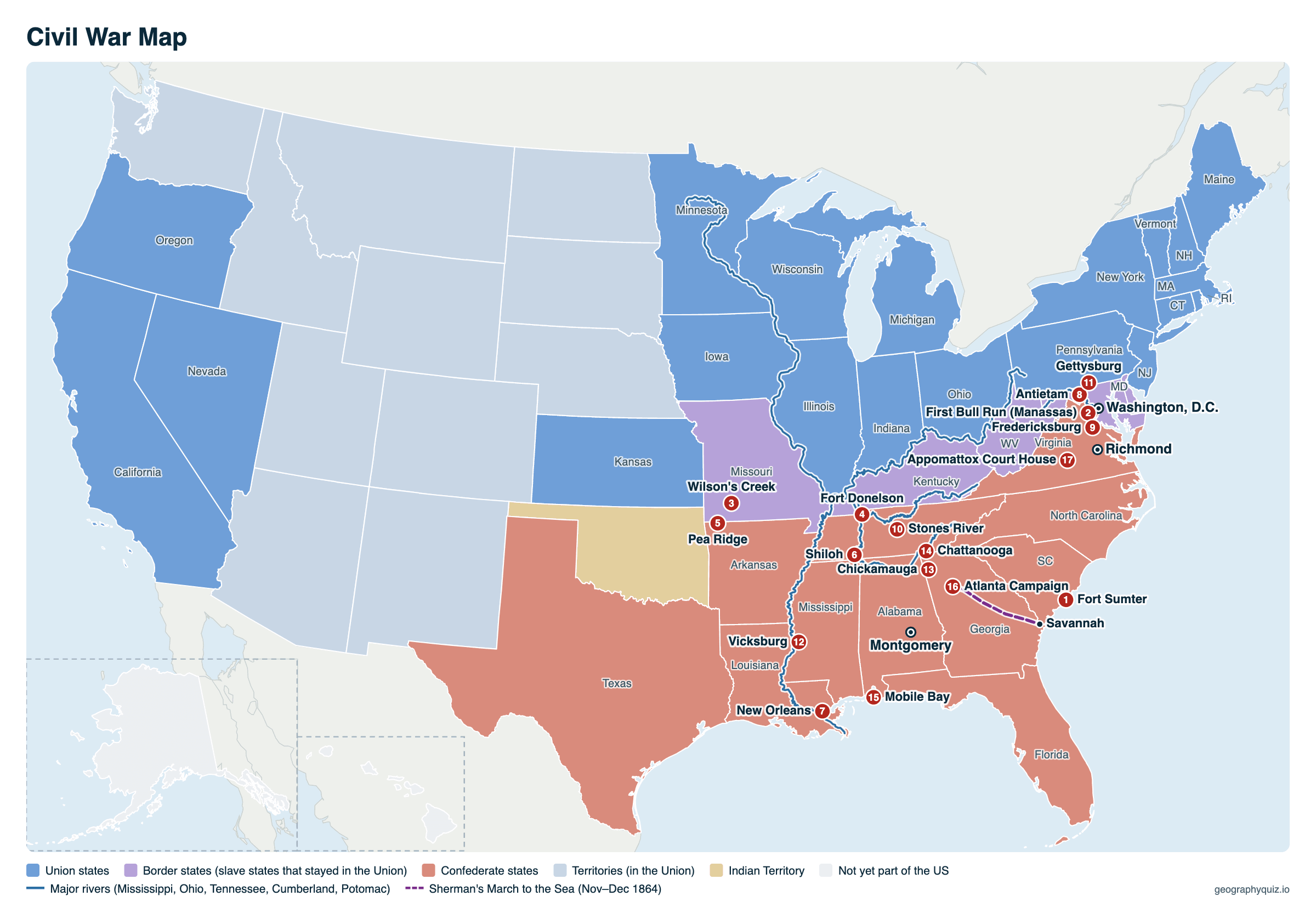
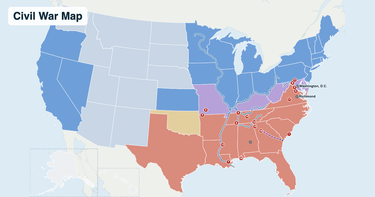
The United States in the Civil War (1861–1865): the 11 Confederate states, the Union, the border slave states that stayed in the Union and the western territories, with 17 of the war's major battles, Sherman's March to the Sea and the rivers that shaped the fighting. Hover over or tap a state for when it seceded or which side it was on, and a battle for its date and who won.
- Union states
- Border states (slave states that stayed in the Union)
- Confederate states
- Territories (in the Union)
- Indian Territory
- Not yet part of the US
States are drawn with their modern borders. West Virginia (1863) and Nevada (1864) are shown as the states they became during the war. The 1861 territories were Washington, Nebraska, Utah, New Mexico, Colorado, Dakota and Nevada. Indian Territory is shaded over all of today's Oklahoma, but the panhandle was then unorganized land outside it.
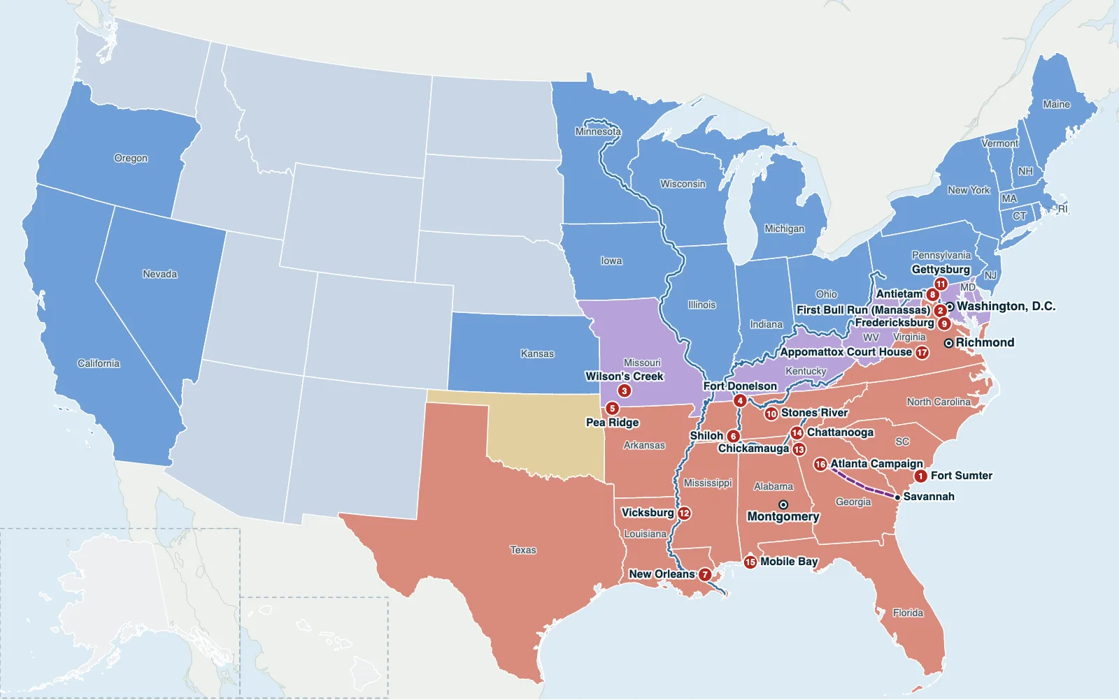
Hover over or tap a state, line or place for details. Use the key to show or hide lines.
Test yourself on this map
Find US States on the Map · Click each state we name
Printable Civil War Map
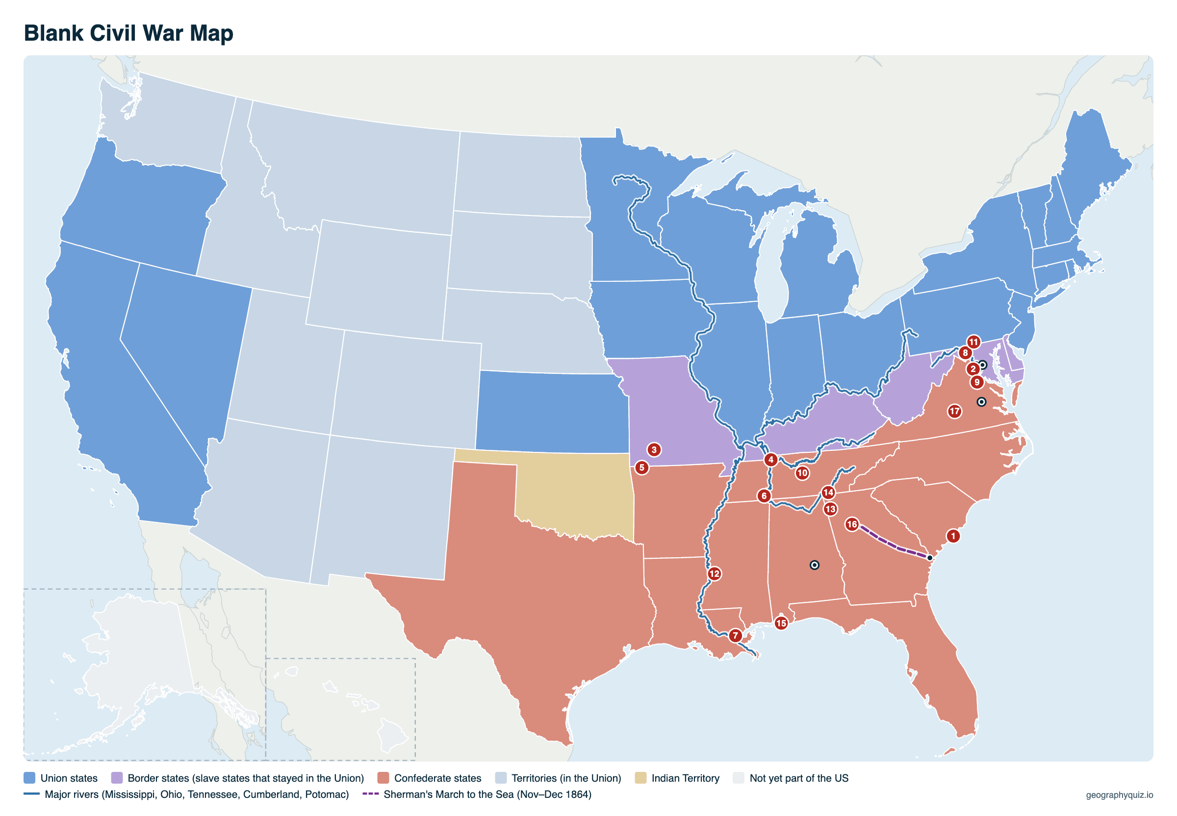
Free to print for class and home: the Union, Confederate and border states and the territories, with the capitals, the major rivers, Sherman's March and 17 numbered battles, on one landscape A4 or US Letter page. The battle numbers stay on the blank map, so students can name each battle from the list. The blank version has the same map with no names on it, for labeling in class.
Key facts
- Dates
- April 12, 1861 – April 9, 1865 (Lee's surrender; the last Confederate forces surrendered by June 1865)
- Confederate states
- 11
- Union states
- 23 in 1861 (25 with West Virginia and Nevada)
- States in 1861
- 34 (36 by 1865)
- Border states
- Delaware, Maryland, Kentucky, Missouri (and West Virginia from 1863)
- Capitals
- Washington, D.C. (Union); Richmond, Virginia (Confederate, after Montgomery)
- First battle
- Fort Sumter, South Carolina
- Deaths
- About 620,000 soldiers (recent estimates up to 750,000)
Union and Confederate states
Which side each state was on in 1861. West Virginia split from Virginia during the war, and Nevada joined in 1864.
| Side | States |
|---|---|
| Confederate (11) | Alabama, Arkansas, Florida, Georgia, Louisiana, Mississippi, North Carolina, South Carolina, Tennessee, Texas, Virginia |
| Union (free states) | California, Connecticut, Illinois, Indiana, Iowa, Kansas, Maine, Massachusetts, Michigan, Minnesota, Nevada (1864), New Hampshire, New Jersey, New York, Ohio, Oregon, Pennsylvania, Rhode Island, Vermont, Wisconsin |
| Union (border slave states) | Delaware, Kentucky, Maryland, Missouri, West Virginia (1863) |
| Territories | Colorado, Dakota, Nebraska, Nevada (to 1864), New Mexico, Utah, Washington; Arizona and Idaho from 1863, Montana from 1864 |
Order of secession
Seven states of the Lower South seceded after Abraham Lincoln's election in November 1860 and formed the Confederate States of America in February 1861. Four more left after the attack on Fort Sumter in April 1861, when Lincoln called for troops.
| # | State | Seceded | Wave |
|---|---|---|---|
| 1 | South Carolina | December 20, 1860 | Lower South |
| 2 | Mississippi | January 9, 1861 | Lower South |
| 3 | Florida | January 10, 1861 | Lower South |
| 4 | Alabama | January 11, 1861 | Lower South |
| 5 | Georgia | January 19, 1861 | Lower South |
| 6 | Louisiana | January 26, 1861 | Lower South |
| 7 | Texas | February 1, 1861 | Lower South |
| 8 | Virginia | April 17, 1861 | Upper South, after Fort Sumter |
| 9 | Arkansas | May 6, 1861 | Upper South, after Fort Sumter |
| 10 | North Carolina | May 20, 1861 | Upper South, after Fort Sumter |
| 11 | Tennessee | June 8, 1861 | Upper South, after Fort Sumter |
What were the border states?
The border states were the slave states that did not secede: Delaware, Maryland, Kentucky and Missouri, joined in 1863 by West Virginia. They lay between the North and the South, and keeping them, above all Maryland around Washington, D.C., and Kentucky on the Ohio River, was one of Lincoln's main goals early in the war.
Kentucky first declared itself neutral, and both Kentucky and Missouri had rival pro-Confederate governments that the Confederacy recognized, which is why both appear on the Confederate flag's 13 stars. The Emancipation Proclamation of January 1, 1863, freed enslaved people only in the states in rebellion, not in the border states; slavery ended everywhere with the 13th Amendment in December 1865.
Major Civil War battles on the map
The numbers match the map. Most of the fighting was in Virginia, between the two capitals, about 100 miles apart, and in the West, along the Mississippi, Tennessee and Cumberland rivers. Chickamauga's marker is drawn a little south of the battlefield, which lies about 10 miles south of Chattanooga, so both show.
| # | Battle | State | Date | Result |
|---|---|---|---|---|
| 1 | Fort Sumter | SC | April 12–13, 1861 | Confederate victory; the war begins |
| 2 | First Bull Run (Manassas) | VA | July 21, 1861 | Confederate victory |
| 3 | Wilson's Creek | MO | August 10, 1861 | Confederate victory |
| 4 | Fort Donelson | TN | February 11–16, 1862 | Union victory; Grant takes 12,000 prisoners |
| 5 | Pea Ridge | AR | March 7–8, 1862 | Union victory; Missouri stays in Union hands |
| 6 | Shiloh | TN | April 6–7, 1862 | Union victory |
| 7 | New Orleans | LA | April 1862 | Union victory; the Union navy takes the South's largest city |
| 8 | Antietam | MD | September 17, 1862 | Inconclusive; Lee's invasion of Maryland ends |
| 9 | Fredericksburg | VA | December 11–15, 1862 | Confederate victory |
| 10 | Stones River | TN | December 31, 1862 – January 2, 1863 | Union victory |
| 11 | Gettysburg | PA | July 1–3, 1863 | Union victory; Lee's invasion of the North ends |
| 12 | Vicksburg | MS | May 18 – July 4, 1863 (siege) | Union victory; the Union controls the Mississippi |
| 13 | Chickamauga | GA | September 18–20, 1863 | Confederate victory |
| 14 | Chattanooga | TN | November 23–25, 1863 | Union victory |
| 15 | Mobile Bay | AL | August 5, 1864 | Union victory; the Union navy closes the port |
| 16 | Atlanta Campaign | GA | May – September 2, 1864 (Battle of Atlanta, July 22) | Union victory; Sherman takes Atlanta |
| 17 | Appomattox Court House | VA | April 9, 1865 | Lee surrenders to Grant |
Frequently asked questions
How many states were there during the Civil War?
Thirty-four when the war began in April 1861: Kansas had become the 34th state that January. Eleven of them seceded to form the Confederacy. West Virginia (1863) and Nevada (1864) joined during the war, so there were 36 states when it ended.
How many states were in the Confederacy?
Eleven: South Carolina, Mississippi, Florida, Alabama, Georgia, Louisiana and Texas seceded before the war began, and Virginia, Arkansas, North Carolina and Tennessee after the attack on Fort Sumter in April 1861.
How many states were in the Union during the Civil War?
Twenty-three in 1861, counting the four border states: 19 free states plus Delaware, Maryland, Kentucky and Missouri. West Virginia (1863) and Nevada (1864) made 25. Kansas had joined as a free state in January 1861.
What were the border states in the Civil War?
Delaware, Maryland, Kentucky and Missouri: slave states that stayed in the Union. West Virginia, formed from Virginia's western counties in 1863, is usually counted as a fifth.
What started the Civil War?
Slavery and its spread to the West. After Abraham Lincoln, who opposed the expansion of slavery, won the 1860 election, seven slave states seceded and formed the Confederacy. The fighting began on April 12, 1861, when Confederate guns fired on the US Army's Fort Sumter in Charleston harbor, South Carolina.
What was the South called during the Civil War?
The Confederate States of America, or the Confederacy. Its soldiers were called Confederates or, by the Union side, Rebels; "Dixie" was a popular nickname for the South. The Union side was called the North, the Union or the United States.
Where was the first battle of the Civil War?
Fort Sumter, in the harbor of Charleston, South Carolina. Confederate guns opened fire on April 12, 1861, and the fort surrendered the next day. The first major land battle was First Bull Run (Manassas), Virginia, on July 21, 1861.
What was the bloodiest battle of the Civil War?
Gettysburg, Pennsylvania (July 1–3, 1863), with about 51,000 casualties on both sides. Antietam, Maryland (September 17, 1862), was the bloodiest single day in American history, with about 23,000 casualties.
Why did West Virginia become a state?
Virginia's western counties, where few people were enslaved and many opposed secession, refused to leave the Union in 1861. They formed a loyal government and were admitted as the state of West Virginia on June 20, 1863.
Which side was Oklahoma on in the Civil War?
Oklahoma was not yet a state: most of it was Indian Territory, home to the Cherokee, Choctaw, Chickasaw, Creek and Seminole nations. Their governments signed treaties with the Confederacy in 1861, though many of their people fought for the Union.
When did the Civil War end?
Robert E. Lee surrendered the Army of Northern Virginia to Ulysses S. Grant at Appomattox Court House, Virginia, on April 9, 1865. The other Confederate armies surrendered over the following weeks, the last in June 1865.
Sources
- State boundaries: US Census Bureau, cartographic boundary files (2024), drawn with modern borders.
- Secession dates and battles: National Park Service, Civil War battle summaries (American Battlefield Protection Program), the American Battlefield Trust and the states' ordinances of secession.
- Rivers: the rivers of our US map.
- Battlefield locations: National Park Service units (Fort Sumter, Manassas, Shiloh, Antietam, Fredericksburg and Spotsylvania, Gettysburg, Vicksburg, Chickamauga and Chattanooga national parks, Appomattox Court House).